Some Early Season Backpacking in Colorado
The weather this spring has been quite wet in the mountains of southwest Colorado with frequent rain and thunderstorms, almost like an early monsoon pattern. The unsettled weather has dissuaded me from attempting any high camps in the snow so far, but with a hankering for some backpacking I have been seeking out some lower elevation destinations this May for some quick backpack outings.

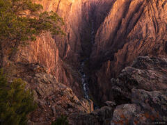
Evening light at the bottom of the Tomichi Route in the Black Canyon - May.
In early May I hiked down the Tomichi Route from the south rim of Black Canyon National Park and spent a night camping at the bottom next to the Gunnison River. Normally emerald green, the Gunnison was more of a murky olive brown due to the high runoff from the spring snowmelt (despite the numerous upstream reservoirs).
The Tomichi Route was the seventh inner canyon route I've hiked into the Black Canyon, and probably my least favorite so far to be honest, just because the bottom is completely rocky so there's not really any idyllic place to camp or even hang out, and literally only one small spot flat enough to fit a tent. I'm being nitpicky, though, as any journey into the depths of the Black Canyon is bound to be spectacular!

Ponderosa pines and granite cliffs in Browns Canyon Wilderness Study Area.
A week later I drove east past Gunnison and over Monarch Pass to check out Browns Canyon. For many years whenever I've driven Hwy 285 between Salida and Buena Vista I've been intrigued by the boulder formations in these foothills east of the Arkansas River, and I figured now would be a good time to go check it out.
With no particular destination in mind, I set off into the Browns Canyon Wilderness Study Area to see what I would find. Almost immediately I was charmed by the landscape of lovely ponderosa forests amidst jumbled granite boulders, with views of the high Sawatch peaks to the west.

Setting sun illuminates ponderosa pines in Browns Canyon Wilderness Study Area. Can you spot my little tent nestled under the pine trees?
I soon discovered the one problematic aspect of backpacking at Browns Canyon which is the utter lack of water, though this was somewhat expected as this is a dry area in the rain shadow of the massive Sawatch Range. The springs marked on the map were not springs after all, and I eventually had to detour my route to go filter water directly from the Arkansas River. After filling up my dromedary bag I bushwhacked up a ridge and eventually found a super cozy campsite nestled under the canopy of a group of ponderosa pines. I spent the rest of the evening exploring and scrambling around granite outcroppings, doing my best impression of the native bighorn sheep.

A colorful sunset over the Sawatch Range, as seen from Browns Canyon Wilderness Study Area. Mount Antero (14,276 ft.) is the prominent mountain on the right.

Sunset over the Morrow Point Reservoir in Curecanti National Recreation Area, just upstream of the Black Canyon National Park.
After my night at Browns Canyon I spontaneously decided to spent another night out down by Morrow Point Reservoir in Curecanti National Recreation Area, since it was pretty much on my way home. Though I arrived a bit too late in the afternoon to take a dip in the chilly water, it was a pleasant place to spend the evening camped "lake"-side in the pinyon forest.