Evolution Loop
In early September Claudia and I continued our Sierra highlights tour, driving down from Tahoe to Bishop along the foot of the rugged and impressive peaks of the Eastern Sierra. We loaded up our backpacks for the longest trek of our summer road trip: a 7-day, 54-mile route through the John Muir Wilderness in the Eastern Sierra from North Lake to South Lake - a near-loop that would take us through Evolution Basin, an area which we've heard numerous people describe as the heart of the Sierra and one of the favorite highlights of the John Muir Trial and Pacific Crest Trail.
I've only done two short backpack trips in the high Sierra before, and that was 20 years ago! So as Sierra newbies Claudia and I got to experience this range with fresh eyes and I'll talk a bit about some of the impressions I had during our week-long trek.

Hiking into Humphreys Basin having just crossed over Piute Pass on a cold, cloudy, and windy day in early September.
After a night in Bishop, in the morning we parked our truck at the North Lake trailhead parking lot, stashed a bin of leftover food and toiletries in the bear locker there, then started hiking up towards Piute Pass. I was hoping to camp up high in the vast and open landscape of Humphreys Basin, but once we crossed over the pass the frigid winds and ominous clouds convinced us to abandon those plans and continue hiking down into the valley where we'd have more shelter in the trees.

Hiking through the forest on our way to Hutchinson Meadow, trying not to get eaten alive by mosquitoes.
In retrospect we should have camped somewhere soon after we reached treeline, but we continued hiking downhill towards Hutchinson Meadows, deep in the valley. We soon regretted our decision once we were swarmed by mosquitoes in the forest! Arghhhh!!! After our previous mosquito-free backpack trip in Tahoe we had figured that all the mosquitoes were gone for the season, but no, they were still out in force here even in September. Finally after 12 miles of hiking and dozens of little creek crossings we set up our tent near Hutchinson Meadow not far from the raging Piute Creek.

Our tent on granite ground near Hutchinson Meadow.
As we were setting up the tent, I was a bit baffled when another hiker stopped and started setting up his tent not even a hundred feet from ours. I'm used to the relative solitude of western Colorado where campers typically spread out and avoid each other, so this seemed quite strange to me that someone would have the nerve to set up camp right near us! But soon enough I realized the error of my thinking when two more campers set up their tents nearby in the same meadow. Turns out that this is pretty normal along the routes of the busy John Muir Trail and Pacific Crest Trail, with so many thru-hikers who hike all day and plop down at the obvious campsites in the evenings. I also noticed that the thru-hikers are way more efficient at packing up camp than we are; by the time we were sipping coffee in the morning, all the other campers had already silently packed up and hit the trail!

Looking down the rugged lower reaches of Piute Canyon.
On Day 2 we continued down through the impressive granite walls of Piute Canyon until reaching the South Fork San Joaquin River. We were anxious to soon find out whether we could continue our trek as planned, or if we'd have to completely scrap our plans and do an entirely different spontaneous loop in the other direction.
Here's the thing: the Sierra had an epic winter in 2022/23 and sometime during the winter or spring, the steel bridge over the South Fork San Joaquin River had collapsed from the sheer weight of snow. All summer long the South Fork San Joaquin River was raging with snowmelt between sheer mountainsides, and with no bridge to cross there was no reasonable way to connect that stretch of trail up to Evolution Basin. The majority of thru-hikers hiking the John Muir Trail or Pacific Crest Trail were detouring around the east side of the range via Piute Pass and Bishop Pass - the exact opposite route we came and were going!
Finding up-to-date info about the river crossing status was nearly impossible online prior to our trip, and along the trail so far we only got some vague secondhand info about the river crossing. When we reached the San Joaquin River, we saw an ominous Forest Service sign warning that the bridge was out ahead and hikers would be turned around. Still, we wanted to see it with our own eyes instead of just giving up, so we continued hiking up the valley towards the dreaded river ford.
After a while we were greatly relieved to see the first hikers coming from the other direction and they told us that fording the river was doable. Whew!

Hikers ford the South Fork San Joaquin River in early September.
When we got to the place to ford the river, I quickly realized that it was all much ado about nothing - the river was only knee deep and no problem at all to cross! Granted, the river had certainly gone down a LOT by early September; it would have been a much different story a month earlier. But still we had a laugh that everyone was still stressing about this easy-peasy ford. And it was a big relief to know that we could continue on our trek up Evolution Creek!

Deer grazing next to Evolution Creek, in Evolution Valley.
Our excitement to reach Evolution Valley was soon dashed by swarms of mosquitoes. The lazy meandering river and expansive marshlands and meadows is a mosquito heaven, and they chased us for miles up the valley. Any thought of camping in this valley was out of the question and our only hope was to push on up to Evolution Lake where maybe there might not be so many skeeters.
Exhausted after another unexpectedly long 16-mile day of hiking, as we neared Evolution Lake the spectacular scenery energized our tired legs and we were practically skipping by the time we reached the lake! We dropped our packs on a lovely broad granite slab campsite and though I was 100% ready to chill, the sun was setting soon so I had to grab my camera and go scurry around to find some photo spots... which was not difficult at all here! The only problem was deciding where to aim the camera when everything looked amazing in every direction!

The setting sun illuminates a waterfall flowing out of Evolution Lake.

Mount Spencer reflects in Evolution Lake at dusk.
So far it was only the second day of our trek and we'd already come much farther than we'd planned and were already a day ahead of schedule! The reward was a full rest day at Evolution Lake.
The mosquitoes were a nuisance at the lake in the morning, so we moved our campsite up onto a granite hilltop high above the lake where there was a fairly steady breeze to keep the buggers at bay most of the time.

The emerald waters of Evolution Lake, with Mount Spencer and Mount Huxley rising above.

Sunset light shines on the peaks surrounding Evolution Basin.
In the afternoon on our rest day we scrambled up above the lake for a more panoramic sunset view of the landscape around Evolution Lake.

Dusk light over Evolution Basin, in the heart of the Sierra.
John Muir famously called the Sierra the "Range of Light" and here I started to understand why. The nearly-white granite peaks positively glowed under a pastel dusk sky after sunset. With mostly clear skies during this trek my favorite light was always this post-sunset alpenglow light.

A stone path across the broad and shallow Evolution Creek above Evolution Lake.
One advantage of hiking along the heavily trafficked John Muir Trail and Pacific Crest Trail (which overlap here) is the backcountry "infrastructure" like this perfect stone pathway over this broad creek at the start of Day 4 of our trek.

Hiking along the John Muir Trail towards Wanda Lake and Muir Pass. Plenty of snow still lingers in the high peaks in early September due to the record breaking snowpack of the previous winter.
We had actually planned for an 8-day trek because on this 4th day I wanted to head off trail to spend a night at a remote lake in a seldom-visited side-basin. So we left the trail and scrambled over boulder fields until reaching a low pass heading into the basin I was excited to visit. But the second I laid eyes on that basin I knew it wasn't happening - the entire basin was nothing but an endless pile of rocks and boulders and I knew that scrambling the 1.5 miles down to the lake would take hours of grueling and probably dangerous rock hopping. We barely even had to discuss; it was obvious that we would be retreating back to the trail towards Muir Pass.
I was a bit disappointed that the reality of my hidden basin didn't match what I had envisioned, but at least I learned another lesson about the Sierra: off trail route planning may not be as simple as studying maps, and not because of impenetrable forest like in Washington, for instance, but because of endless rock fields!

The John Muir Memorial Shelter sits atop Muir Pass at 11,955 feet elevation.
Although our little detour proved to be fruitless, we were happy to get back onto the trail up Muir Pass, where we took a break at the stone John Muir Memorial Shelter.
A plaque inside the shelter reads: 'The John Muir Memorial Shelter was erected in 1930 to commemorate America's leading early conservationist and first president of the Sierra Club. Conceived by Sierra Club "High Trip" leader William Colby, inspired by the Italian Trullo hut building tradition, and designed by Bay Area architect Henry Gutterson, the rustic alpine shelter endures as a fitting tribute to Muir's great passion for preserving wilderness and his legacy for our national parks.'

A mind-bending vertical-panoramic view inside the John Muir Memorial Shelter.
After crossing over John Muir Pass we descended down, down, down through a seemingly never-ending chain of linked basins and lakes until we found a decent campsite overlooking Le Conte Canyon.

Hiking over huge suncups on lingering snowpack in September after a very snowy previous winter.

Our tent perched on a cliff above Le Conte Canyon.
On a side note, I am mostly enamored with our Tarptent Dipole Li tent which I think is pretty much the ultimate 2-person trekking-pole-supported tent design; however, on this trek I learned that this type of tent isn't the best choice for the Sierra. The reason being that trekking pole tents require good staking for support, but tent stakes are mostly useless when you're frequently camping on granite slabs! Indeed, so far on this trek we had camped on granite slabs every single night. After long days of hiking, the extra hassle to set up rock anchors instead of stakes starts to become a nuisance, especially in tight campsites like the one above. Next time I go backpacking in the Sierra I'm definitely going to bring a freestanding tent with poles!

Langille Peak (12,018 ft) is a granite behemoth that dominates the landscape in Le Conte Canyon.
Our 5th day of hiking was easily the most spectacular day of hiking of the trek: surrounded by sheer granite mountains down through Le Conte Canyon, then epic views of those same burly mountains as we climbed up out of the valley towards Dusy Basin. Even the juniper trees here are gigantic. On this day the Sierra just seemed to be flexing!

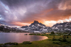
Twilight glow on Isosceles Peak and its rugged granite neighbors in Dusy Basin.
Dusy Basin is another Sierra gem: a highly scenic basin with numerous lakes below rugged 13ers and 14ers, and right in the middle of that is the photogenic granite needle of Isosceles Peak. Of course I could not resist shooting my take of the classic photo of Isosceles Peak reflected in one of these lakes. Even though I didn't luck out with any sunset clouds on this evening, the twilight afterglow on the granite peaks was still a sight to behold!
While I was here gazing up at the ultra rugged ridges of Mount Agassiz, Mount Winchell, and Thunderbolt Peak, I thought about how I'm glad that I don't identify as a bigtime peak bagger back home in Colorado - because I'd be humbled real quick here in the Sierra where the 13ers and 14ers are a whole 'nother level of burly. I doubt that climbing 14ers is a very popular hobby in California since probably most people wouldn't even consider it!

These strange and slightly creepy looking clouds over Mount Agassiz were harbingers of a thunderstorm that arrived that night.
Though we still had one more night left and could have stayed another evening in Dusy Basin, the weather forecast was calling for high winds, so we thought it would be prudent to get over Bishop Pass before the nasty weather arrived.

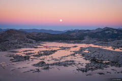
Camping under the stars below Mount Goode as clouds stream in, harbingers of a very rainy night.
After so many high camps, our final camp at the low elevation Long Lake felt quite bucolic and the stiff breeze was most welcome to keep any mosquitoes from swarming us. That evening clouds started streaming over, and in the middle of the night they unleashed with rain and thunder! We were definitely glad we didn't have to ride out that storm up above treeline in Dusy Basin!
Fortunately the rain eased off in the morning, though we only had about three miles to walk down to the trailhead at South Lake. Shortly after we arrived at the parking lot there, we were able to hitchhike in the back of a pickup truck with some visiting fishermen who drove us most of the way back to our truck at North Lake, thus concluding our spectacular trek through this rugged and beautiful stretch of the Sierra!
Alabama Hills
Feeling pretty grimy after our 7-day trek, we stopped in Lone Pine for showers at the Chevron gas station there (yes, that is a thing you can do), then continued to Alabama Hills to camp in the truck for a night.
Alabama Hills is such a striking place: a desert landscape dotted with outcroppings of surreal granite boulders, with Mount Whitney and its neighboring peaks towering nearly 10,000 vertical feet behind. Because of this classic rugged "western" landscape (and relative proximity to Hollywood), hundreds of western movies and television shows have been filmed here over the years, and we ended up camping along the aptly named "Movie Road".

Late afternoon sunbeams shine through curtains of rain at the granite outcroppings of Alabama Hills. Mount Whitney and the Eastern Sierra rise nearly 10,000 vertical feet higher.
If the landscape wasn't awesome enough as we drove through the granite hills, late afternoon sunbeams were shining through the jagged peaks, illuminating curtains of rain passing over the desert. Stunning!!!

Late afternoon sunbeams shine through curtains of rain in front of Mount Whitney, the tallest peak in the continental US at 14,505 ft (4,421 m).

We found a fantastic spot to camp with a panoramic vista overlooking the desert and mountains, and had a lovely evening cooking dinner, drinking beer, soaking in the views, and decompressing after our big trek. The vista was so spectacular and the truck camping so relaxing that ironically I thought this might be better than anything we experienced during our big week-long trek through the mountains!