Hanging Around Glacier Peak
In late August/early September I spent 9 days backpacking a 95-mile loop route around Glacier Peak, a volcano in the central Cascades of Washington. One of the more remote and wild volcanos of the Northwest, Glacier Peak is also unique in that it rises not solitarily but amongst a plethora of other surrounding rugged peaks and ranges in its namesake wilderness area. Strong hikers can trek around Glacier Peak in about 4-5 days, but I opted to hike for 9 days because I wanted to incorporate a number of side trips along the way. As an added twist for my trek, I left the tent behind and hammock camped the entire way. This turned out to be one of the most amazing and adventurous treks I've done!

White River Falls
The idea for this trip was born out of frustration with the drought and wildfire smoke that had been plaguing Colorado (and much of the western US) in August of this horrifying year that is 2020. Though I'd had a busy and productive backpacking season close to home in Colorado up until then, by mid-August the dry conditions and persistent smoky air had squashed any motivation or excitement for further backpacking trips around here. Looking despairingly at the smoke map every day, I could see that although almost the entire western US remained blanketed by smoke and haze, the Washington Cascades seemed to be the only spot with clear air. I kept muttering that it would be a great time to do a road trip up there, though I never really pursued the thought further since it just seemed like a distant dream. Finally on one particularly smoky day it dawned on me that I could actually just bust out there, drive straight to a trailhead, do a big trek, then head right back home without much COVID hazard potential. It would have to be a solo trip, since my wife Claudia had other obligations. But I ran the idea by her, and she was fine with it (probably happy for me to do anything to improve my sulky mood!).
With a newfound surge of excitement, I spent the next day researching possible routes. Looking for a week-long loop trek, I started by browsing the topo maps on CalTopo. I honed in on a possible network of trails that connected to form a circuit around Glacier Peak in the Glacier Peak Wilderness, an area I've long wanted to explore ever since I lived briefly in Washington in 2001-2002. I mapped out the route, then googled around to find any additional helpful info, eventually stumbling upon RobinB's excellent trip report which provided a helpful dose of reality regarding some of the challenges to expect along the way.

With my route planned, I spent the next two days packing my backpack and my truck, then I hit the road. Stayed one night with my parents in Utah, one night at a campground in eastern Oregon, then soon enough there I was at the White River Falls Campground just north of Lake Wenatchee near Leavenworth, Washington, surrounded by huge mossy trees and a turquoise river flowing by. Welcome to the Northwest, woohoo!!! Early the next morning after pre-dawn coffee and breakfast burritos I shouldered my heavy pack and started my walk into the wilderness.
I was brimming with excitement for this trek. First and foremost, I was eager to see and explore the Washington Cascades again - I've always loved this range, so different in character than my home Colorado mountains. I was also excited to do a long, adventurous, and challenging trek; in fact this 9-day trek would be the longest self-supported trek I've yet done! To add to the adventure, it was going to be interesting to do my first real long trek with a hammock instead of a tent. And of course, it would be nice to escape all the wildfire smoke for a while.

Anyways, thanks to Robin's trip report I knew to expect some tough bushbashing on the neglected and overgrown trail up the Indian Creek valley on my first day's hike. It's a good thing I expected this, as otherwise I probably would have been totally discouraged and wondering about whether the whole trek would be this way! The Indian Creek trail is there, it's just so overgrown that you have to bash through the bushes for miles and miles, occasionally stopping to figure out where it went. At first I thought it wasn't so bad, but it just got progressively thicker and thicker until after several hours I was cursing at every plant that whacked me in the face or tripped me up. But eventually as I got toward the upper end of the valley the plants lightened up and finally at the saddle above the valley I reached the well worn Pacific Crest Trail. Smooth sailing from there on out. While I would encounter some thick trail sections and a bit of bushwhacking on later days of the trek, the worst of it was behind me.

Sunset behind Sloan Peak (7,835 ft.).
I'd previously done four short backpack trips with the hammock in Colorado this summer, which helped to get the equipment dialed in, but I'm still pretty much a newbie with the whole hammocking experience. This was the first long multiday trek I've done with it - an intensive 8-night crash course in hammock backpacking. It seemed that nearly every day during the first half of this trek I learned another valuable lesson.
Hammock Lesson #1 was a painfully stupid one: After picking out a good spot to hang my hammock on the first evening, as I went to attach my tree straps I was dismayed to realize that my Colorado tree straps were too short to wrap around the trees! Yes, apparently trees in the Northwest are larger than in the Rockies! So stupid of me to forget about this. It would remain an issue throughout the trek, always narrowing down my potential hang options since I could only use the smaller trees.

Pacific Crest Trail near White Pass.
The second morning's hike was glorious, taking me along the Pacific Crest Trail over high ridgelines and mountainside trails with immense vistas, including the first views of Glacier Peak as I crossed over Red Pass. Super stoked to be in the Cascades again.
I could see that I was probably a couple weeks late from what looked like a spectacular wildflower season up there, but on the bright side the bugs weren't bad and there were ripe huckleberries all over the place!

A view of Glacier Peak from the headwaters of the White Chuck River valley below Red Pass.

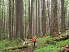
Majestic forest in the White Chuck River valley.
The trail brought me down from the alpine zone into the forest of the White Chuck River valley. These Northwest forests are so majestic and enchanting, with the massive trees, moss, and ferns.
My first detour side-trip was to take the old trail from the defunct Kennedy Hot Springs up to Lake Byrne. This used to be one of the most popular zones in the Glacier Peak Wilderness, but a massive flood in 2003 wiped out the hot springs, campground, and access trail, so the route has since been largely forgotten and neglected. Because of this I naively expected to be the only visitor at the once-popular Lake Byrne. But upon arriving I was a bit disappointed to find it quite crowded, with nearly every campsite already occupied. I ended up hanging my hammock in a crazy spot on a steep hillside above the lake.

Moonset light on Glacier Peak, reflected in Lake Byrne.

A hillside hammock spot above Lake Byrne, as the sun rises over Glacier Peak.
My second night taught me Hammock Lesson #2: While appealing in theory, hammock camping on a steep hillside sucks. First off, if I or the hammock had fallen down, I would have tumbled uncontrollably down the slope. Also, it's no good camping on a hillside where I kept slipping and there's no easy place to put my stuff down. At least it made for a nice picture, though.

Looking up at Glacier Peak (10541 ft / 3213 m) above Kennedy Ridge.
Day 3 was another grueling but fantastic hiking day, descending from Lake Byrne then continuing on the Pacific Crest Trail along a wonderful high stretch to Fire Creek Pass. (It was fantastic except for the part where I got attacked by a swarm of little wasps and stung four times before I ran away!). Along the way, I passed the closest I'd come to Glacier Peak itself, just below Kennedy Ridge. Pretty awesome to gaze up at the glaciers tumbling down the sides of the volcano.

A view down the White Chuck River valley, with Mount Pugh (left) and White Chuck Mountain (right).
I stopped for lunch at this amazing view looking down the White Chuck River valley towards Mount Pugh and White Chuck Mountain. Mount Pugh has a special memory to me, as it was the very first hike I ever did in the Cascades when I moved (briefly) out to Seattle after college back in 2001. Coming from Colorado, the view from atop Mount Pugh pretty much blew my mind - the sheer scale of the mountains around there was next level. And just so very much different in character than what I was used to in Colorado. Anyways it was fun to see that mountain again and reminisce about those days nearly two decades ago when everything seemed so new to me in Washington.

The south side of Dome Peak (8920 ft / 2719 m) as seen from far away on Fire Creek Pass.
Topping out at Fire Creek Pass, I could see that some rainy weather was slowly moving in from the ocean, and sure enough a few raindrops started falling as I descended past Mica Lake. Though it had been another long day of hiking, I kept hiking further and further than I intended since I hadn't found a suitable campsite with water and trees to hang my hammock. Finally just as night fell and it really started raining, I found a good spot and strung up my tarp and hammock.
Then, Hammock Lesson #3 happened. My mistake this time was that I had attached my tarp and hammock to a fairly thin larch tree which initially seemed sturdy enough, but when I sat down in my hammock it promptly sagged and hit the ground as the flexible larch tree bent under my weight. So then in the pouring rain I had to figure out how to simultaneously move both my hammock and tarp without getting the hammock wet, which was basically impossible though I eventually got it sorted out (with much cursing during the process). So, lesson learned: no flexy trees with the hammock!

A foggy hammock camp below Mica Lake.
By the morning the rain had stopped but fog shrouded the mountains and forest. The morning's hike down through the foggy forest was quite mystical and photogenic. Really feeling the Northwest vibes.

A foggy forest along the Pacific Crest Trail.

A foggy forest along the Pacific Crest Trail.
This fourth day of hiking was yet another long, grueling day, capped at the end with an off-trail bushwhack (and water haul) along a spur ridge of Glacier Peak which ends at a high point that offers an incredible panoramic view looking back towards the volcano and its neighboring mountains. Of all the destinations I had planned for this trek, this was the one I was most excited about, and so I was thrilled and feeling super lucky to make it out here during decent weather, especially considering the rainy weather just the night before.

Misty clouds sweep past Glacier Peak (10541 ft / 3213 m).

A fantastic hammock camp with a mega view of Glacier Peak.
I was fortunate to find a good hammock hang spot near the top of the ridge point, offering a massive hammock vista of Glacier Peak. This was the first spot where I really felt that the hammock camping was paying off bigtime, as there would have been no way to camp anywhere nearby here with a tent, given the lack of any flat ground.

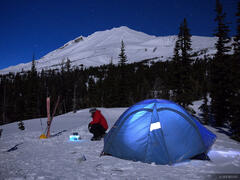
Full moon rises over the Washington Cascades.

A panoramic view of Glacier Peak (10541 ft / 3213 m) from the north just after sunset.
That night after setting up camp, taking sunset photos, and having dinner, I finally laid down and got cozy in my sleeping bag in the hammock. By then the clouds had formed a full inversion layer covering the valleys and ridges below, leaving me on an island over the sea of clouds, looking over towards Glacier Peak which was illuminated by the full moon. This was one of those utterly sublime moments that will be forever etched in my memory, and also it capped this feeling of everything coming together - all the effort of driving out to Washington, all the grueling days of hiking so far, all the hammock learning - all of it had come together to arrive at this one sublime moment. I dozed off with a giant grin on my face.

Day 5 would be hiking down, down, down, from my high point all the way down to the depths of the Suiattle River, the giant river that oddly wraps halfway around Glacier Peak from its southwest side to its northwest.
Along the trail I passed by countless salmonberry bushes which provided lots of snacking opportunities. Salmonberries are similar to raspberries, but perhaps a bit more tart. Oftentimes perfectly ripe, juicy, dark red salmonberries would be dangling right at arm height next to the trail, allowing me to pick them in stride without even missing a step!

Majestic old growth trees along the Suiattle River.
Along the south side of the Suiattle River is one particular area of majestic old growth forest with jumbo ancient trees. My neck was getting sore from gazing upwards so much.
I spent that fifth night camped alongside the roaring Suiattle River, then on Day 6 I woke up early and got started on the endless switchbacks heading up toward Miners Ridge and the famous Image Lake, which would be third side-trip detour of my trek.

Rainy, misty weather atop Miners Ridge.
By the time reached the top of Miners Ridge the weather was drizzly and I put my lightweight umbrella to good use while I hiked.

Rain soaked huckleberries in early September.
As I mentioned before, during this entire trek at the higher elevations the mountainsides were covered with huckleberry bushes filled with ripe and delicious huckleberries! Always a trailside treat, even in the rain I couldn't resist stopping occasionally to feast a bit.

A beautiful sunrise at Image Lake, with Glacier Peak rising behind.
With its picturesque view of Glacier Peak from across the valley, Image Lake is a popular destination with many backpackers. Due to its popularity camping is not allowed in the lake basin itself, but rather the campsites are tucked away on the other side of the little ridge on the left side of this photo. This situation helps preserve the wild nature of this pretty area. Interestingly, this lake reminded me a lot of typical alpine scenery in Colorado - while we don't have towering volcanos we do have plenty of little paradisiacal alpine lake basins like this one!
This was my sixth day on the trail and for the first time yet on this trek I finally had a chance to chill! I arrived at camp fairly early and had the whole afternoon to dry out damp gear, wander around the lake, and generally just relax and recuperate for once. So far on this trek I'd been doing about 13-mile days - hiking basically all day long and having just enough time at camp to do my chores, take some photos, then go to bed. In fact I had gotten stuck behind schedule - arriving at camps fairly late, going to bed late, then sleeping in just to recover from exhaustion, then repeating. Finally having a chance to get caught up and go to bed early put me back on track. Plus, from here on out my hiking days weren't quite so long and punishing, so for the second half of my trek I had lots more time to relax and actually enjoy soaking in the scenery.
Which brings up the point that for sure my favorite thing about backpacking is in fact the chill time! While it's great to be hiking through such wonderful scenery, for me really the best part of it all are those moments when all the obligations are taken care of and I can just sit around and soak it all in, letting my thoughts wander, and sort of quietly absorbing the beauty of nature.

Brilliant sunrise light illuminates the summit of Glacier Peak (10541 ft / 3213 m).

Glacier Peak on a clear blue sky day.
On Day 7 I hiked from Image Lake towards Buck Creek Pass. I loaded up on water from the springs at the pass, then headed up around Liberty Cap for a lonely high camp in the high meadows up there. This was another great hammock camp that wouldn't have really been possible with a tent on the sloping mountainside.

Hanging out in my hammock at a high meadow with a big view of Glacier Peak.

Sunset behind Glacier Peak as a bit of wildfire smoke hangs in the sky.
That evening some wildfire smoke started to move in from the south. It made for a nice sunset, but in the morning I woke to the distinct smell of wildfire, and indeed the mountains were full of smoke haze. I learned later that this smoke was from wildfires that had started in eastern Washington, which sadly have become massive infernos in the days after I left Washington.

Sunrise light touches the summit of Glacier Peak.

A view of Glacier Peak from High Pass.
Day 8 brought me over High Pass, down through the Napeequa River valley, across the Napeequa River, and up to Boulder Pass, where I planned to camp for one last night before descending back to the White River where I started my trek. High Pass was highly scenic but I admit I was in a foul mood while walking through the hot and fly-infested Napeequa valley.
As I ascended toward Boulder Pass, I thought about how much I'd love to have a super chill and cozy camp for that final evening - could the gods of the Cascades just grant me that one wish? As if on demand, right over the pass I found the perfect clear hammock spot right above a gurgling spring creek, surrounded by loaded huckleberry bushes! A literal candyland camp.

Heaps of wild huckleberries in early September.
In the afternoon I spent an hour or so harvesting a plate full of huckleberries, then sat in my hammock and gorged on those while contemplating the important question - Is it better to eat huckleberries one by one, or by the hand-full? After much experimentation, I concluded that it is indeed best to load up your entire mouth at once with huckleberries for the full flavor explosion.

The spires of Clark Mountain above Boulder Pass.
My ninth and final day was just a matter of packing up one last time and hiking downhill for 4,000 vertical feet back to my truck at the White River trailhead. After reaching my truck and ditching my backpack, I put my sandals on, grabbed a change of clothes, headed back up the trail for a few minutes to a nice river shoal, and took a much needed full body bath before hitting the road for the long drive back home.

A small forest scene in the White River valley.
For years I've been yearning to get back to Washington for some more backpacking, and this 9-day loop trek around Glacier Peak was a big satisfying dose of Cascades! I'm already excited for my next visit, whenever that may be.