Hut to Hut in the Hohe Tauern
After two fun-filled weeks of visiting Claudia's family in Germany, in early September we (along with Claudia's dad Gundolf) headed south to Alps for an 8-day hut-to-hut trek through the Hohe Tauern National Park in Austria. Basically a meandering north to south crossing of the Hohe Tauern range, our route started from near the town of Kaprun, took us right past Grossglockner (the tallest mountain in Austria), and ended in the town of Mörtschach – while staying at alpine huts for seven nights along the way.

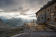
The Kitzsteinhorn (3203 m) towers above the alpine reservoirs of Mooserboden and Wasserfallboden, as seen from the Heinrich-Schwaiger-Haus hut at sunrise.
These two reservoirs are held back by some of Austria's tallest dams, which were constructed starting during World War II using prisoners of war from Belgium and Jewish and Soviet forced laborers. Construction was halted in 1943, then restarted after the war in 1947 by Allied-occupied Austria. Built with American equipment and massive help from the Marshall Plan, the dams and hydroelectric power plant became an icon of post-war reconstruction, and are now a popular tourist attraction as well. (Source)
Our first day of the trek was action packed: a 6-hour drive from Dresden to Mittersill, two buses to Kesselfall, another bus up through winding tunnels through the mountain, a steep funicular cog-tram-thing, and one more bus up a road switchbacking up the steep mountainside to the Mooserboden. After walking across the two impressively massive dams, an 800m (~2600 ft) vertical hike got our blood flowing until we finally arrived at our first hut – the Heinrich-Schwaiger-Haus, perched on a single flat spot along an otherwise steep ridge below the Fochezkopf.
The stiff hike up seemed a bit pointless as we arrived in the clouds and saw nothing but gray fog the first evening. But the morning brought clear skies and an epic view looking back down over the two massive reservoirs and surrounding peaks and glaciers.

A massive waterfall thunders over the cliffs below the rapidly melting Karlingerkees glacier.
It wasn't until our second day hiking past this booming glacier-fed waterfall that I really started feeling the Alps vibes. You don't see this back home in Colorado!
Our hike from the Heinrich-Schwaiger-Haus to the Rudolfshütte was way longer than we expected and we finally arrived exhausted after over 10 hours of hiking! But what a good place to relax after a long day; the Rudolfshütte is not really a hut – it's a full-on hotel in the mountains with a gondola going to it. It's got rooms with showers, as well as a sauna, pool, restaurant and bar, and even a climbing wall!

Hocheiser (3205 m) reflects in a small tarn at sunset.
Despite my exhaustion from the day's hike, I put the boots back on and hiked back to some little lakes that I had scouted out on the way up and was pleased to catch a nice sunset reflection shot before heading back to the hotel for a much deserved hefeweisen.

A cloud bank pours over the Tauernkogel at dusk.

The Rudolfshütte sits on a hill above the Weißee reservoir. Reachable by gondola, the Rudolfshütte is a full blown hotel in the mountains, complete with restaurant, bar, pool, sauna, and even an indoor climbing wall! In the winter it's the hub of a small ski area.
Day 3 was an "easy" day which was appreciated after our big second day. We just had to cross over one pass, then a long descent took us to the Kalser Tauernhaus where we had the rest of the afternoon and evening to eat kaiserschmarrn, nap, relax, drink more hefeweisen, and play kniffel (Yahtzee). After the modern hotel of the Rudolfshütte it was nice to experience an old, traditional, cozy Alpine hut again.

The Kalser Tauernhaus alpine hut is located in the Dorfertal valley in Hohe Tauern National Park. Built in 1928-1930, in the 1970's and 80's the hut and the entire Dorfertal valley were threatened by a proposed hydroelectric reservoir project, which wasn't withdrawn until 1989. Perhaps ironically, the hut is now powered by its own small scale hydroelectric power generator. (Source, and historical photos)

Hiking out of the Dorfertal valley along a precipitous path carved into the steep mountainside.
On our fourth day we hiked out of the Dorfertal and around to the Teischnitztal, on our way to the Stüdlhütte, the highest hut of our trek situated on a saddle below Grossglockner.

Grossglockner as seen from the southwest. The Stüdlhütte is situated on the round saddle below the peak.
Well rested from our previous easier day, the 1200m / 3900 ft ascent up the Teischnitztal to the Stüdlhütte went by surprisingly smoothly. Once we had hiked up through the forest and a rocky gorge, the upper Teischnitztal opened up into a broad valley with our first views of Grossglockner, the tallest mountain in Austria! We all agreed that this valley reminded us of the Cordillera Huayhuash in Peru, with its barren grassy slopes with glacier-clad peaks above.

The Stüdlhütte sits on a high saddle directly south of Grossglockner.
The Stüdlhütte is a popular base for climbers attempting Grossglockner, the "Everest" of Austria. As such, the hut is busy and hectic, full of guides teaching their clients how to put crampons on. Here we also learned (to our dismay) that the Austria Alpine Club had just recently ended their Covid restrictions that previously kept the huts at half capacity, meaning that that night we had the dubious pleasure of sharing a bunk room (and its stale air) with about 20 other random sweaty, stinky hikers. I know everybody these days acts like Covid is "over" but this was not my idea of a comfortable situation, even pre-pandemic. Oh well.

Dusk light illuminates Grossglockner (3798 m / 12460 ft), the tallest mountain in Austria, as seen from a southern ridge.
I was still stoked to catch an up-close photo of the impressive south face of Grossglockner from a small peak above the hut. As you can probably guess from the photo, the glaciers have dramatically receded here in recent decades. Of course this is not news to anybody, and most alpine huts have old photos hanging on the walls that show much larger glaciers 50-100 years ago. Gundolf (who has climbed Grossglockner from the right-side ridge) talked about how he had previously once crossed that slope on the right side - all on thick glacier.

Hiking below Grossglockner.
Our fifth day of hiking was probably the most fun hiking day of the whole tour – a long meandering traverse from the Stüdlhütte to the Elberfelder Hütte.

A spicy trail traversing a steep section of mountainside.
Along the way the path crossed over some steep exposed sections, though these sections always had a cable to hold on to.

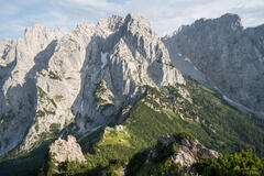
Hiking below striking geological formations.

Clouds gather around Grossglockner, the tallest mountain in Austria.
As we neared the last pass before descending to the Elberfelder Hütte, we had awesome views looking back towards Grossglockner. This mountain has such a classic, iconic shape! I could hardly keep my eyes off of it.
I had dreams of shooting a sunset photo from a nearby peak that evening, but the weather was not cooperating so I reluctantly continued on down to the hut. (This is always a tough decision to make, but in this case it was the right one since it ended up just raining that evening).

Hiking towards Großer Hornkopf (3251 m).
The mountains around here seemed to have a notably different character compared to the first half of our trek through the Hohe Tauern. Here the mountains reminded me a lot of Colorado (on steroids), with the mix of colorful red-toned rocks and open tundra basins. The resemblance was so uncanny to me that I actually kind of felt strangely at home.
Another thing I'll mention about this valley is that when I was planning this trip I didn't really think much of it; there didn't seem to be any standout peaks, any lakes, or really anything that looked particularly interesting. It was just a logical stopping point during the trek. But once we actually got here I just loved it! The whole landscape was just unexpectedly beautiful.

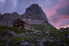
A bit of sunlight illuminates the Elberfelder Hütte.

Almost to the Elberfelder Hütte.
The Elberfelder Hütte also turned out to be our favorite hut of the entire trek! It's a classic, quiet, cozy hut with a nice layout and a friendly hut keeper. We also had our own room again which was refreshing after the crowded Stüdlhütte experience.

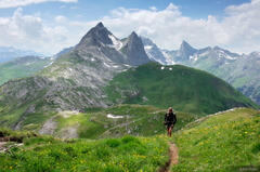
Hiking past a pond in the Hohe Tauern.
On Day 6 we took the "scenic" [long] route from the Elberfelder Hütte to the Adolf-Nossberger-Hütte. And scenic it was, especially once we crested over the last pass and hiked down the receded-glacial-rock-slabyrinth route to the hut.

Hoher Perschitzkopf (3125 m) reflects in an alpine pond.

Hiking to the Adolf-Nossberger-Hütte.

The Adolf-Nossberger-Hütte is situated between two turquoise lakes; the Großer Gradensee is the one visible on the right.
The valley and lakes and peaks around the Adolf-Nossberger-Hütte also blew away my expectations. Just an absolutely stunning place.

Hiking above the Großer Gradensee and Adolf-Nossberger-Hütte, with Petzeck (3283 m) towering above.
On our seventh hiking day we had to race a rainy weather forecast to the Wangenitzeehütte. Once again, what looked like a fairly short day on the map turned out in reality to be a respectable day of hiking. I think the issue with me is that I'm used to reading topo maps in feet, and the topos in the Alps look pretty much the same except everything's in meters... and much bigger! (Or perhaps the previous two weeks in Germany stuffing myself with Obazda and hefeweisen had something to do with it!).

Some curious sheep looking for snacks.

The beautiful emerald lakes of Wangenitzee, situated in a high basin ringed with mountain peaks. If you look closely you can see the Wangenitzeehütte on the hill at far left.
The Wangenitzeehütte overlooks a series of emerald lakes situated in a high basin. Though I was a bit tired from hiking that day and rain was threatening, I couldn't resist exploring around the lakes for a couple hours before heading in to the hut.
So far on this trek we'd been super lucky with the weather and never actually got rained on at all while hiking! But that evening a storm rolled in and the lightning was insane that night with flashes almost every ten seconds at times.

Heavy rain and misty forests in the Hohe Tauern.
On our eighth and final day, we finally had to hike through pouring rain, but what better day for wet hiking than the last day!? We just had to make a long descent in the rain down the valley towards the village of Mörtschach, where we caught buses back around the mountains to where Gundolf's car was parked in Mittersill.
All in all, this trek through the Hohe Tauern was a lot more strenuous than I expected but we were rewarded with seeing a wide variety of mountains and huts and a close encounter with Austria's tallest mountain, and it was great to spend some more mountain time with Claudia's dad too!