Journey Around the San Miguel Range
Recently I've had an itch to do an adventurous high-mileage trek - something with long hiking days to whip my winter beer belly into shape. With snow still clinging to the alpine basins in early June here in the San Juan Mountains of Colorado, I knew the best place to trek would be something in the lower-elevation subalpine zone where the aspens are green as can be and the meadows are filled with flowers. Basically I wanted to do something like the hike from Ouray to Telluride that I did a few years ago.
One idea I've been kicking around in my head for a while is to hike a complete circumnavigation of the entire San Miguel Range near Telluride, closely skirting the boundary of the Lizard Head Wilderness which encompasses the range. I mapped out a 60 mile loop route connecting a series of rarely used trails, lonely dirt roads, a short stretch of highway walking, and even a bit of bushwhacking to keep me sharp. With a light pack, I planned on 4 days of hiking, for an average of about 15 miles a day - which for me is doable, but a challenge for sure.

Glorious spring green aspens carpet the valley below Dolores and Middle Peaks in the San Miguel Range - June.
I parked at Woods Lake on the northwest corner of the range and started my clockwise trek via the Wilson Mesa Trail first. There are many options for where to start this trek, but I chose this spot because the first day had a forecast of high winds from the southwest so I figured it would be a good idea to be on the more forested leeward side of the range first where the winds hopefully wouldn't be so nasty.
Anyways, immediately past the trailhead I was fully immersed in the glorious greens of springtime aspens! I know the golden aspens of autumn get the most attention, but the spring green is just as exhilarating in my opinion - the jubilant opening act of summer rather than the bittersweet climax.

Dandelion fields forever.
After about 8 miles or so the trail crossed this eye-popping meadow full of bazillions of dandelions! I knew I should probably hike further that day, but the aspen-ringed, flower-filled meadow was just too idyllic to pass up. I called it a day and set up camp in the aspens at the edge of the meadow.

Aspens provide a pleasant shady place to sit next to a dandelion-filled meadow on a warm spring day.
What is it about aspen trees that is so incredibly beautiful? The way the white boles rise so straight and clean? Perhaps it's the gentle rustling sound the leaves make as they flutter in the breeze, or the way they glow like stained glass in the sunlight. Hiking through pine forests can be a bit dreary at times, but the moment you enter an aspen forest the entire mood changes to a divine, uplifting atmosphere. The birds seem to like them too, with their singsong chatter serving as my morning alarm clock.

An idyllic campsite in some aspens next to a mountain meadow.
Did you know that aspen boles are connected with the same root system underground? Each individual "tree" is actually a sprout of the same larger organism, so an entire aspen grove might actually be one single tree. This makes aspens the most massive living beings on our planet! Imagine a centuries-long timelapse of an aspen grove sprouting new boles as the older ones die off, the whole thing gradually morphing and meadering over the mountainsides as the years fly by. I wonder how old an ancient aspen grove may be. Thousands of years? Tens of thousands? Hundreds of thousands? Millions of years old? Perhaps the aspens have witnessed the rise and fall of the mountains themselves, migrating up and down the hillsides as the glaciers came and went.

Sunset light filters through aspens in the San Miguel Range near Telluride, Colorado.

Three bull elk graze on a meadow after sunset.
Along with the aspens, elk were a common companion during this trek. Ever wary of humans, they will startle at the slightest movement seen from hundreds of yards away, but don't seem to mind too much a still human with a camera sitting quietly on the edge of their meadow.

Wilson Peak (14,016 ft.) towers above a green forest of aspens.
I've noticed that for some reason some people around here don't seem to be too familiar with the "San Miguel" name of this range, but everybody knows Wilson Peak, of Coors beer can fame. Wilson Peak certainly has one of the most iconic and beautiful profiles of any mountain in Colorado, easily recognizable during the drive up to Telluride.

A lovely creek meandering through a green mountain meadow in the San Miguel Range.
Having only hiked 8 of my necessary average 15 miles on the first day, I had a serious mileage deficit to catch up on during the next days. I tried not to think about that too much - nothing to do but just keep on walking and enjoy the scenery and greenery along the way.

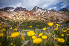
Looking up towards the high peaks of the San Miguel Range.

A dazzling carpet of dandelions below Wilson Peak.
By midday I was on the Galloping Goose Trail which follows the abandoned railroad grade from the old Rio Grande Southern Railroad which operated from 1890 - 1951 and connected Ridgway, Telluride, and Durango. Now the railroad is long gone and all that's left here are a few remnant railroad ties.

Remnants of railroad ties from the old Rio Grande Southern Railroad which ran from Ridgway to Durango with a branch to Telluride. Built by Otto Mears in 1890, in the 1930's the steam locomotives were supplemented with automobiles that were converted to rail cars - later named the "Galloping Goose". The railroad was abandoned in 1951 and this stretch is now a hiking and biking trail above the town of Ames.
After crossing above Ames and a steep and quick bushwhack shortcut, I had to do about 15 minutes of road walking along Highway 145 before re-connecting to the Galloping Goose Trail again as it works its way up towards Trout Lake then Lizard Head Pass.

Trout Lake, a popular recreation spot near Telluride.
Upon reaching Trout Lake, I made the mistake of continuing along the Galloping Goose route which makes a huge detour around the lake. I thought this would be preferable to walking along the highway, but it added two miles to an already ridiculously long day! I should have just stuck to the highway directly to Lizard Head Pass. Oops...
As I was walking up the dirt road nearing Lizard Head Pass, I was surprised and delighted to randomly to run into my friends Mike and Cheri who were out for a walk! We chatted for a half hour or so and I was seriously tempted to abandon my trek and just hitch a ride and go grab beers with them instead. But I was on a mission so I reluctantly said goodbye and continued my long march. By the way, if you haven't seen Mike Anderson's photography, you've got to check it out now!
This second day of hiking ended up being well over 20 miles, which was a record for me. Fortunately I felt good so far - my body working smoothly with no knee or back pains! I found a flat little meadow next to a creek, washed up, ate dinner, then hit the sack - exhausted but strangely enough, eager for the next day of hiking.

A creek flows through expansive meadows below Mount Wilson, the tallest 14er in the San Miguel Range at 14,250 feet.
Day 3 was hiking along the Groundhog Stock Driveway which crosses through enormous wide open meadows along the south side of the San Miguel Range. Not a soul in sight except for the elk, and I started to wonder why more people aren't into this sort of early season lower elevation backpacking? Everybody waits for the standard summer backpack trips to turquoise alpine lakes and 14ers and whatnot, but there's so much more than that out there! Anyways, whatever... I'll enjoy it for myself if nobody else wants to!
On a different note, on this trek (and many similar treks in Colorado) there's usually plenty of clear streams to get water during the day. I use a SteriPen UV water purifier which is perfect since I can quickly stop, dunk my bottle in the stream, purify it, and be on my way. No waiting for filtering, pumping, or squeezing. Also, a good strategy is to immediately chug half the bottle - that way I stay constantly hydrated while only needing to carry half a liter of water weight or less.

A happy little trail through happy little aspens.
When planning my route I studied various map sources like the Forest Service maps, the old USGS topos, and the Nat Geo Trails Illustrated #141 map for the north San Juans. Between those various maps I was able to find some old trails that are marked on some maps but not others - like for example the old connector trail between the Kilpacker and Navajo Lake trails.

Aspenglyph from 1917.
The western end of the Groundhog Stock Driveway felt like the most wild section of my hike so far - clearly not used very often and the scant evidence of humans was very old indeed. Odd to think that someone was right here carving this aspen over 100 years ago, while World War I was raging overseas. Just mind boggling how much the world has changed in a couple generations. I bet we can't hardly fathom what day to day life was really like back them. For the aspen, it's probably pretty much the same - though perhaps a bit hotter and drier now than it would prefer.

El Diente Peak, 14,159'.
After climbing steeply up to a high mesa, the trail petered out (or I just lost it), and I was left with the map and my own intuition to find my way. Normally I actually enjoy some off-trail bushwhacking, but it's a bit more daunting when you have a lot of mileage to cover! How long would I need to bushwhack? Is there even a trail at all around here? Will I be able to keep on track to finish this route? Those thoughts started bouncing around in my head... but fortunately after an hour or so I reconnected to a solid trail again.

Aspens below Dolores Peak.
By this point in the trek I'd already circled around the main core of the range where all the 14ers are located, and now I began working my way around the lesser-visited western massif including Dolores and Middle Peaks.

Backlit aspens and a lonely back road in the western San Juan Mountains.
After the Groundhog Stock Driveway I had a seemingly endless stretch of road walking for the rest of the day. These remote dirt roads could almost be considered just wide trails since the surrounding scenery is absolutely lovely and pristine and I only saw a couple vehicles the whole time.
Day 3 ended up being another grueling 20+ mile, 11-hour hiking day, and I was still walking at sunset until I found a decent campsite next to an irrigation ditch near the road. Though the camp spot wasn't ideal, at least I had finally paid off my mileage debt that I had accrued from the first short day of hiking.
While I was certainly exhausted and wrecked after two 20+ mile hiking days in a row, I've been equally exhausted many times before after hiking only half that far but with a heavy pack. This really proves in my mind how crucially important pack weight is for hiking performance (and enjoyment). There's absolutely no way I could have hiked this distance with heavy gear and lots of camera equipment (I only brought my camera with one lens on this trip). This is why I often geek out on ultralight backpacking gear - every single ounce saved truly makes a difference.

I *think* these are Deadly Galerina (Galerina marginata), one of the most poisonous mushrooms in Colorado. Consumption can lead to kidney and liver failure within 24 hours.
Having done two monstrous 20+ mile days in a row on the second and third days, for the fourth and final day I only had a casual 8 miles left to return to my car at Woods Lake. However, to my dismay this ended up being another tough day - the reason being that the Lone Cone Trail is essentially abandoned and nearly impassable due to heaps of deadfall covering the trail. In some sections there are three or four levels of downed trees lying on top of each other, with the same as far as you can see on either side of the trail. No choice but find a way to climb over and through that mess.

Nightmarish deadfall smothers the abandoned Lone Cone Trail. Yes, there was a trail in there somewhere.
I actually felt really lucky that I had knocked off all that mileage the previous two days, because this frustrating deadfall situation would have been an absolute nightmare at the tail end of a high mileage day. A situation like that could quickly turn dangerous and lead to exhaustion, injury, or at least a hike that extends well after dark. But fortunately I was able to take my time and keep calm while working out each deadfall puzzle one by one.

Looking up at Dolores and Middle Peaks from near Woods Lake, with vibrant greenery everywhere.
Once I was below the pines and back in the more hospitable aspens, the deadfall wasn't a problem any longer and I enjoyed a nice stroll back down towards Woods Lake where I started from four very long days ago!

The first columbine spotting of the summer.
The loop trek around the San Miguel Range offered all the challenge and adventure I had hoped for! It was a fantastic early summer route to do in late May or early June, but I would hesitate to recommend it mainly due to the problematic deadfall stretches of the Lone Cone Trail, though a decent alternative could be to do a longer route of road walking on 618 instead of the Lone Cone Trail. While my goal was to circumnavigate the entire range including Dolores and Middle Peaks, if I did this again in the future I'd probably axe out that part and just take the pass over from the Navajo Lake Trail to the Woods Lake Trail, which would make for a shorter and sweeter loop trek as a whole.
As I write this journal my toes are a bit numb but I'm already excited for the next backpack trip, whatever that may be. I can guarantee it will be shorter, though!