Khumbu Three Pass Trek
In October and November of this last year, Claudia and I fulfilled lifelong dreams to trek in the mighty Himalaya of Nepal – the world’s biggest mountains. We spent 20 days trekking the so-called “Three Pass Trek” over three high passes and through the four major valleys of the Khumbu/Everest region. Of course everybody knows about Mt. Everest, the world’s tallest mountain, but often overlooked is the fact that Everest is just one of many other enormous, spectacular mountains in this range. It’s a dream destination for mountaineers and trekkers alike.
Join me here as I share some highlights and snapshots from our three week trek through these magnificent mountains!

Flight from Kathmandu to Lukla.
The adventure begins with a gripping flight from Kathmandu to Lukla, a Sherpa village with a mountainside airstrip, often listed as the most dangerous airport in the world.

View of the cockpit during flight from Kathmandu to Lukla.
We board a rickety old worn-out airplane in Kathmandu, fly along the Himalaya, pass right over soaring mountain ridges, then swoop down into a deep valley towards the tiny airstrip. There’s only one shot at a landing — no circling around for a second try here!
![Approaching Lukla. Prepare for [hopefully] landing!](https://www.mountainphotography.com/images/xl/20141018-Lukla-Aerial-3.jpg "Lukla Aerial 3")
Approaching Lukla. Prepare for [hopefully] landing!
Sooner than expected, trees are flying past the airplane window, the roar of the propellers echoes off the fast approaching ground, and suddenly the plane is rolling up the runway. The passengers erupt in applause, knowing that surely we’ve all narrowly escaped death. It all felt like a roller coaster — but a roller coaster with no guarantee of survival.

Happy to be alive after successfully landing at Lukla.
The harrowing flight into Lukla is a shortcut that saves five days of strenuous trekking through the foothills from Jiri — something that every visitor once had to do before the airstrip was built. Although I’ve heard that the trek through the foothills is very much worthwhile, I must admit it was nice to get right to it in Lukla.

An airplane prepares to take off from the mountainside launch ramp that is the Lukla airport.
Our guide Bismu (who we had hired via a trekking agency in Kathmandu) was waiting there for us at the airport. In Nepal it is very common for trekkers to hire guides and/or porters. Bismu is a guide/porter, so he carried a spare bag of ours and also led the way and helped us to find a lodge every evening.

Chhuthawa
The Khumbu region is the home of the Sherpa people, who have been living in these valleys and mountains for hundreds of years. The Buddhist influence is everywhere to be seen; carved prayer stones, stupas, prayer flags, and prayer wheels adorn the trails, especially in this lower valley.

Village of Phakding.
The valleys of the Khumbu are dotted with little Sherpa villages, which traditionally were occupied by farmers and shepherds but have increasingly become more tourism-based, to house and feed the thousands of trekkers that flow through each year. So this is not so much a wilderness trek, but rather a cultural trek. Tents and camping are not necessary whatsoever; each night is spent in a village “teahouse” — a lodge that provides meals and a basic room to sleep in. The teahouses even have menus; mostly variations of fried rice and fried noodles, momo dumplings, or the ubiquitous dal bhat, a delicious all-you-can-eat Nepali meal of rice and lentils with curry.

A stupa and prayer flags in Thamserku.
Even during the first days of hiking up the Dudh Koshi valley, the power and immensity of the mountains here is clearly apparent. In the photo above, the snowy peak Thamserku rises over 12,000 vertical feet above the river! That’s more than twice the depth of the Grand Canyon!

Prayer stones

At the official gateway to Sagarmatha National Park, this sign says: "While visiting this special area, visitors are encouraged to: 1) Refrain from taking life, 2) Refrain from anger, 3) Refrain from jealousy, 4) Refrain from offending others, 5) Refrain from taking excessive intoxicants. Enjoy your visit!"
This sign is so Nepal. I like it.

Crossing a high bridge over the Dudh Koshi, on the way to Namche Bazaar.

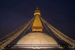
A stupa at the entrance to Namche Bazaar.
The second day of hiking from Lukla brought us to Namche Bazaar, a Sherpa village perched at 3440m /11,286 ft elevation in a basin high above the Bhote Koshi gorge. This is the main trading and tourist hub of the Khumbu region, and a wonderful place to relax and spend a few days acclimatizing to the altitude.

Lodges in the Sherpa village of Namche Bazaar.

Namche Bazaar is a Sherpa village perched in a basin high above the Bhote Koshi gorge. This is the main trading and tourist hub of the Khumbu region.

First major views of Mt. Everest (far left) and Ama Dablam (right).
We had a “rest” day in Namche Bazaar but actually spent most of the day doing a loop hike to the nearby village of Khumjung and back. On this hike we got our first views of the higher mountains where we’d be heading soon.

The town of Khumjung, where people are busy sticking yak dung on the stone walls, to dry in the sun and later be used as fire fuel for warmth and cooking.

The Buddhist monastery in Khumjung houses a well guarded yeti scalp.

Prayer wheels at the monastery in Khumjung.

Lunchtime in a quiet teahouse in Khumjung.

A monument to Sir Edmund Hillary, who was the first person to reach the summit of Mt. Everest, and who has also contributed much to the Khumbu people including founding the school here in Khumjung.

Hiking deeper into the Khumbu, with Thamserku (6608m / 21,680 ft) towering overhead.
A typical day of hiking here is only about 4-6 hours. The reason for the fairly slow and steady pace is to allow your body time to acclimatize to the high altitudes, which just get progressively higher and higher as the trek goes on. People who try to rush through here run a serious risk of developing altitude sickness.

A stupa with prayer flags below Thamserku (6,608 m / 21,679 ft).
After Namche Bazaar our next destination was Tengboche, the site of an important Buddhist monastery.

A Buddhist mural greets arrival at Tengboche.

An ornate gateway entrance to the Buddhist monastery at Tengboche.

Ama Dablam and the Buddhist monastery at Tengboche.

Ama Dablam towering over Pangboche village.
Although Mt. Everest gets all the fame and glory, in reality it is a shy, unattractive hulk that sits aloof and hidden from most perspectives. The real star of the show here is Ama Dablam, a beautiful, symmetrical spire that dominates the view for much of the trek.

A porter hauls a mattress to another village.
No Khumbu trip report would be complete without the obligatory picture of a porter hauling an insanely huge load. The porters are the backbone (no pun intended) of life in the Khumbu, as they are the ones who haul all the outside food and supplies into the mountains. In a Nepal economy with nearly 50% unemployment rates, it’s no wonder why there are so many porters willing to hump double loads high into the mountains. Sadly it’s oftentimes just big boxes of soda for the tourists.

Smoke from yak dung ovens pours out of a teahouse in Pheriche.

Clouds swirl around Taboche Peak (6367m / 20889 ft) at sunset.

Hiking across the valley from Ama Dablam.
Before embarking on this trek, I had done a lot of research into potential off-the-beaten-track vantage points for unique photo opportunities. One such spot was an obscure high lake with a front-and-center view of Ama Dablam. I dreamt of a sunset reflection shot of Ama Dablam from here, and decided I would try my best to pursue it. It would be the shot of the trip if all the factors lined up. But first I had to get there, which was no small feat. When I finally arrived at the lake in the afternoon, I was pleased to see that it was not frozen! Good first step. Unfortunately, though, the clouds had rolled in by then, completely obscuring the view.
But I bundled up in all my down clothes and sat up there in the clouds and snow waiting for sunset, with some small hope that maybe the clouds would clear in time. To my astonishment and elation, right before sunset the clouds started breaking apart, revealing glorious glimpses of the snowy peak of Ama Dablam!

Ama Dablam (6856m / 22,493 ft) emerges from the clouds.
Soon the clouds were really clearing off, swirling about Ama Dablam in a sublime spectacle.

Thamserku (6608m / 21,680 ft).
Then even more miraculously, the wind died down and the lake started to settle out like a mirror. I ran back down to the lake and gleefully started shooting some reflection photos of the giant surrounding peaks.

Alpenglow light illuminates Ama Dablam. Makalu (8481m, 27,825 ft) is visible at the left side.
I kept shooting through sunset and twilight time; in fact my favorite light in the Himalaya is the post-sunset twilight, when the sky darkens to a deep blue but the peaks still glow brightly with atmospheric light. Needless to say, I felt like a kid on Christmas to be able to photograph the scene above. Lucky, lucky. I worked my way back down in the darkness with a headlamp on my head and perma-grin on my face!

Hiking into the village of Dingboche.

Sunset over Dingboche.
At Dingboche in the middle of the night we were woken up by some booming noises from outside and wondered what it was — rockfall? Looking out the window we could see flashes of lightning, but it was happening below us, way down in the lower valley, while the stars shined brightly above! That’s how big these mountains are…

Ama Dablam at sunrise, as seen from high above Dingboche.
I woke up early that morning to hike up a mountain above Dingboche for sunrise. Again, I found myself in the clouds and snow, this time in darkness with no idea what the weather was doing around me. But I kept going, despite my nearly frozen toes. After a few hours of hiking I started to lose hope and was debating turning around when I noticed a prayer flag pole up ahead and realized I was just a few meters from the top! So up I continued, and yet again to my delight the clouds descended into the valley below me right before sunrise!

Taboche and Cholatse on a frigid October morning.

Relaxing on a teahouse patio in the village of Chhukhung (elevation 4730m / 15,518 ft.) with Ama Dablam overhead.
The next stop: Chhukhung, a small village at an elevation of 4730m / 15,518 ft. Our teahouse there had a big patio with a mind-boggling view of Ama Dablam soaring directly above!

The north side of Ama Dablam at dawn, as seen from Chhukhung.

The northeast side of Ama Dablam.
We spent another “rest” day hiking up to the Imja Tsho lake near Island Peak base camp, through an otherworldly valley surrounded by heavily glaciated peaks, including of course the ever-present Ama Dablam.

A cold outhouse, but a nice view!

Leaving Chhukhung.
Feeling quite fit, strong, and acclimatized by this point, we faced the first big pass of the trek — over the Kongma La.

Hiking up the Kongma La, with Ama Dablam behind.

Hikers crossing the Kongma La.

Almost at the top of Kongma La at 5535m / 18,159 ft.

Some frozen lakes on the rock-covered Khumbu Glacier.
We made it over the Kongma La pass just fine, but after that we still had to cross the Khumbu Glacier to get to Lobuche, the next village. Easier said than done. The cairned route across the rock covered glacier meanders up and down endlessly and became quite an unexpected chore after having crossed the big pass already. Dehydrated and exhausted, we finally made it to Lobuche then promptly both got sick.
The infamous “Khumbu Cough”. In most of the higher elevation villages, you’ll be sitting in the dining room at the teahouses, and half the people there are hacking up a lung. Despite all our precautions (including a daily regimen of vitamins and probiotics), we both caught a nasty cold and were laid out for a day in Lobuche. Fortunately we were able to keep going after only one day out of commission, although the cough and phlegm would stick with me for the remainder of the trek.

The rock-covered Khumbu Glacier.

Hiking towards Pumo Ri (7165m / 23,507 ft.)

Pumo Ri stands tall high above the village of Gorak Shep (elevation 5125m / 16,814 ft.) Gorak Shep is the last village before Everest Base Camp. Kala Patthar is the little brown “hill” in front of Pumo Ri.
At 5125m / 16,814 ft, Gorak Shep is the highest village on the trek and the last outpost before Everest Base Camp. Although the daytime temperatures are surprisingly warm, the nights at this altitude are frigid in the unheated rooms. Waking up was always the hardest part of the day, having to get out of the cozy sleeping bag and get dressed in the freezer box of a room.

Jack and Claudia on Kala Patthar; Everest behind.
The goal of most trekkers’ trips here is to visit Everest Base Camp, where in the spring months there is a huge tent city full of ambitious climbers. But during the months of October and November, despite the typically stable and clear weather, the temperatures and wind chill are just too harsh to climb Everest. With base camp being virtually empty we decided to pass on that and just hike Kala Patthar instead.
Kala Patthar is a sub-peak of Pumo Ri, and at 5540m / 18,176 ft. it offers the must-see classic view of Mt. Everest and Nuptse.

Sunset light on Mt. Everest (8850m / 29,035 ft), the tallest mountain in the world, as seen from Kala Patthar (5540m / 18,175 ft). The pointy mountain in the center, which only appears bigger due to perspective, is Nuptse (7861m / 25,791 ft).
This was a view I knew I wanted to photograph at sunset. And again, I was so lucky with the timing, scoring beautiful clear weather and sublime sunset light. (The days before and after this were all clouded up at sunset). Time and time again on this trek I just couldn’t believe how lucky I was with the weather conditions and photography opportunities!

Panorama of Mt. Everest, Nuptse, and Ama Dablam, as seen from Kala Patthar.
With all the legend and lore of Mt. Everest, it felt surreal and wonderful to actually be sitting there gazing at the tallest mountain on the planet. A dream come true for me, really. And again I have to point out the scale here, as the defining characteristic of the Himalaya is the mind-blowing size and scale of the mountains here. Consider that I’m sitting here on a peak that’s 18,175 feet tall. And Mt. Everest is 29,035 feet tall! I already feel like I’m super high up, and I’m staring directly up at a mountain that is eleven thousand feet higher!

Mt. Everest and Nuptse at twilight, as seen from Kala Patthar.

Yaks

Hiking in the Himalaya.
Satisfied with our time at Gorak Shep and Kala Patthar we made our way back down and around to Dzonglha. We decided to spend another rest day here — an actual rest day — in order to relax, regain some energy, and hopefully recover from the tenacious cold that we caught back in Lobuche. It was also in Dzonglha that we took the most expensive hot showers ever — eight dollars a piece! Had I known the price beforehand I would have just remained stinky.

Hiking below spectacular Cholatse (6335m / 20,784 ft).
The stretch of trail to Dzonglha might be the most spectacular of the entire trek, with views of Ama Dablam and Cholatse towering straight above.

The huge mountain walls near Lobuche reflect in a small pond as the clouds break up.
I found a small lake not so far from Dzonglha which offered great reflection photos of Cholatse and the surrounding mountains.

Reflection of Cholatse.

Twilight glow above Cholatse (6335m / 20,784 ft).
On clear evenings in the Himalaya, maybe fifteen minutes or so after sunset, there is this incredible magenta light that illuminates the sky. I know it’s popular for photographers nowadays to process all their sunset photos to create this kind of artificial overly-magenta sky glow; but here in the Himalaya it actually looks like this. For real.

Hiking from Dzongla towards Cho La.
We departed Dzonglha for Cho La, the second big pass of the trek, at a height of 5330m / 17,487 ft. Although not technically difficult, it’s quite a long hike to the village of Dragnag on the other side.

Hikers on Cho La with Cholatse behind.

Hiking across the Ngozumba Glacier; Cho Oyu (8188m / 26864 ft ), the sixth highest mountain in the world, in the background.
After hiking over Cho La, and a night in Dragnag, we crossed the Ngozumba Glacier — another huge rock-covered valley glacier — and continued up to the village of Gokyo.

Thin-air painting at Gokyo.
Gokyo is situated between the beautiful turquoise Dudh Pokhari lake and the massive glacial moraine wall of the Ngozumpa Glacier.

A view of Cholo (6089m) from the Ngozumpa Glacier.
We spent another rest day hiking to more lakes further up along the Ngozumpa Glacier.

Looking down the Ngozumpa Glacier.

Moon over the Himalaya, as Mt. Everest catches the last glow from the sun, long after sunset.
We hiked up nearby Gokyo Ri at 5360m / 17,585 ft. to witness another glorious sunset over the Himalaya. Long after sunset, when there’s even a few stars out, Everest still catches rosy red light from the atmosphere.

Hiking up Renjo La.
Renjo La was the third and final pass of the trek, and perhaps the most spectacular of all with an awesome view of Everest and company the whole way.

Hiking over Renjo La, with Mt. Everest behind.

Mt. Everest as seen from Renjo La.

Our friendly guide Bismu!

Between Renjo La and Thame.
Hiking down Renjo La and into the valley of Thame felt like the beginning of the end of the trek. We had crossed all our passes and hiked to all our highest points, the initial excitement was gone, and now we were on our way down.

The village of Thame.

A stupa near Thame.

The view from the backyard of Apa Sherpa's teahouse in Thame. Apa Sherpa has climbed Everest 22 times -- more than anybody else in the world. He even had all his Guiness World Record certificates hanging inside.

Back in Namche Bazaar.
Having completed somewhat of a loop, we passed back through Namche Bazaar and enjoyed one more night there.

A view of Namche Bazaar in the moonlight from our teahouse room window.
At dinner I made sure to order a yak sizzler as a congratulatory feast. When that steak came out on the sizzling hot iron platter, you know everyone in the whole teahouse was looking my way!

Bengkar

All that was left was to hike a couple days back down the Dudh Koshi, back the way we came, to catch our flight out of Lukla. It was a bittersweet hike, somewhat shell-shocked from all the huge mountains we had just spent three weeks amongst, but also looking forward to the luxuries of civilization in Kathmandu again.


Celebratory cappucinos and black forest cake at the "Starbucks" in Lukla.
P.S. – As a sort of disclaimer as I wrap up this trip report, I must say that it is incredibly difficult to distill three weeks worth of novel experiences into a one page trip report. Especially frustrating is the fact that there are huge gaps in my photographic documentation of the trip; namely, the glaring absence of people, both Nepalis and fellow trekkers. While some trip reports might represent a full memory of the experience as a whole, in this case a large portion of my experience — including the wonderful people and the rich culture — is missing. For those of you who might have the impulse to go trek in the Khumbu yourself, you can take heart in the fact that you will see and experience a whole lot more than what you’ve seen here! Try to photograph that for me.
P.S.S. – Since I know the question will be asked, most of the hiking photos here were taken handheld with a Sony A6000 camera with 16-70mm Sony/Zeiss zoom lens. Most of the “prints-available” landscape photos were taken on a tripod with a Sony A7R with Canon tilt-shift wide-angle lenses or a Contax/Zeiss 35-70mm lens.
P.S.S.S. – If you are wondering what trekking guide agency we used, I’m sorry but there are so many guiding agencies in Nepal that it is nearly impossible to recommend one over the other. The good news is that it’s very easy to just show up in Kathmandu and figure it out. We simply went to an agency’s office in Kathmandu (there are many) and they lined up our guide/porter for us and booked our plane tickets to Lukla. That was all! This was all done without problem only two days prior to our trek. The guide was already in Lukla and met us there; he gets contracted out by numerous agencies. In my opinion there’s no need to book a tour package type of thing in advance, unless perhaps you have a big group of people to organize.