Knowles/Mee Canyons Loop
After a week stuck at home suffering through Covid, I started feeling better and was hungry for an outdoor adventure - and a long desert trek sounded particularly appealing! I didn't want to drive too far, so during my research I honed in on the canyons west of Grand Junction in the Black Ridge Canyons Wilderness, an area I'd never visited before. Looking at the maps an obvious potential route is a 36-mile loop going down Knowles Canyon, along the Colorado River, then up Mee Canyon. A bit of internet searching revealed that this is indeed a route that some people do, so I knew it was possible!

Entering the Black Ridge Canyons Wilderness near Grand Junction, Colorado.
A 2.5 hour drive from Ridgway through Grand Junction and up onto the northern end of the Uncompahgre Plateau brought me to the remote trailhead of Knowles Canyon where I set off on my adventure.

Big sandstone walls in Knowles Canyon.
The trail meanders through some gentle upper basins before a steep descent into the bottom of Knowles Canyon. I was pleasantly surprised by the general awesomeness of this canyon - this is legit canyon country! As far as geology is concerned, the Colorado/Utah state line is meaningless here.

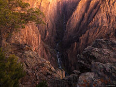
Camping on an elevated slickrock terrace in Knowles Canyon.
After eight miles of hiking I decided to call it a day, so I loaded up with 4 liters of water filtered from the little stream that was flowing in the upper/middle canyon, then scrambled up to an area that looked promising for some slickrock benches. I always prefer camping on slickrock whenever I can, rather than in the dirt and grass. It's so nice to have a clean, open camp area and to be able to hang out in socks or slippers!

Collared lizard.
There are lots of lizards down here. I also saw a golden eagle and some turkeys!

Overlooking the Moore Bottom and Black Rocks area along the Colorado River between Grand Junction, Colorado and Moab, Utah.
Knowles Canyon empties into a broad, grassy area along the Colorado River. This first half along the river was very lovely hiking, especially along the Black Rocks of Moore Bottom, an area where purple granite outcroppings protrude into the river, creating lots of interesting little coves, peninsulas, and beaches that are clearly prized campsites with the rafting crowd.
I read several trip reports about this loop trek before I left, and some people had written about some scary ledges that must be crossed high above the river. I was a bit anxious about this, but the route was cairned and the ledges weren't too crazy after all (though a fear of heights would not be good here). What the trip reports didn't mention was how incredibly rugged the second half of this route along the river would be, with lots of tedious ups and downs and detours working through convoluted terrain. I was relieved to finally emerge from that gauntlet into the open country at the mouth of Mee Canyon.

Impressive sandstone formations in lower Mee Canyon. Pink/purple granite rock lies at the bottom of the canyon, a unique sight in sandstone canyon country.
I was further relieved to find pools of water in lower Mee Canyon, so I knew I would be able to camp soon after a grueling day of hiking. I was hoping to camp near Arch Tower, a spectacular spire that seems to be teetering on the brink of collapse, and I finally arrived here before sunset after about 8 hours and 12 miles of hiking.

Post-sunset light illuminates Arch Tower, a massive spire which seems to be teetering on the brink of collapse.
After photographing a lovely sunset above Arch Tower, I was finally able to set up camp, clean up, filter water, cook dinner, and then just rest my legs and relax for a bit under the moonlight before crawling into my sleeping bag for the night.

Nearly full moon behind Arch Tower.
On Day 3 I resumed my trek up Mee Canyon. The lower canyon is spectacular, full of big sandstone walls and spires. It reminded me a lot of Cedar Mesa, minus the ruins and artwork. Eventually, however, the fun was replaced with frustration further up the canyon where it became more and more of a bushwhack battle. I was at least glad I was doing a one way loop route through here; an out and back through this bushwhack twice would be demotivating to say the least.
During my research before this trip I also stumbled upon a FKT (Fastest Known Time) website forum where some guy reported running this entire loop in 7.5 hours!!! I honestly can't believe that. I mean, I'm not saying he's lying, it's just that my brain cannot accept that a human being could possibly accomplish this, or anywhere even close. I couldn't stop thinking about this, and it kind of made me irrationally angry, as I was thrashing through the streamside mud and reeds averaging probably less than one mile per hour. I didn't keep track exactly but I probably spent a combined total of about 25 hours of hiking on this loop. This FKT dude was going more than three times as fast as I was. Sheesh. Maybe I set the record for SKT (Slowest Known Time).

Looking out from the massive alcove in upper Mee Canyon.
Finally I made it to my next destination: a gigantic alcove in upper Mee Canyon where the stream bend has carved its way deep under the sandstone wall. I had fun shooting some trippy photos in there with the orange bounce light illuminating the giant ceiling.

Bounce light illuminates the enormous ceiling of the alcove in Mee Canyon.

A panoramic view inside the deep alcove in upper Mee Canyon - one of the deepest alcoves of the Colorado Plateau.
With no appealing campsite anywhere nearby (and certainly not in the alcove, which would be a bit creepy!) I decided to load up on water again and hike up out of the canyon to camp on the rim.

The route into (or out of) Mee Canyon has numerous interesting cruxes, including this ladder that leads to a ledge followed by a passage through a small arch.
The route out of (or into) Mees Canyon is quite a thrilling ride! On the way out, first comes about an 8-inch wide ledge that you have to shimmy your way across - not ideal with a full backpack and 4 liters of water! I just went for it and got it done without looking down or thinking about it. Next you have to wriggle through a tiny hole in the wall to get around a corner; I had to push my pack through first, being careful not to drop it off the other side, then squirm through after it. Finally there's a somewhat sketchy old ladder that provides access to another ledge that then passes through a larger arch. Fun stuff! Whoever first scouted out this route - hats off to you, you canyoneering beast!

Camping on a slickrock ledge on the rim of Mee Canyon.
So the third day was another grueler for me, and I was happy to finally set up camp on slickrock again before sunset and have some time to relax and soak in the views.

A bear track in the dirt above Mee Canyon.
The fourth and last day's hike was just a pleasant walk through the pinyon/juniper forest in the high country around the head of Mee and Knowles Canyons back to my truck at the Knowles Canyon trailhead. Near the Mee Canyon trailhead I passed the first other hiker I'd seen the entire time, who was surprised to see me. Later on I walked alongside bear tracks for about a half mile!
All in all this was a fantastic but strenuous trek through seriously awesome canyon country. There's admittedly a lot of "squeeze" for the "juice" so it's likely a one-and-done route for me personally, but I'm happy I did it and am already thinking about other routes to do around here in the Black Ridge Canyons Wilderness! Or maybe I should get into rafting... 😎