Sangres Seven Pass Loop
Looking at a topographic map of Colorado, the Sangre de Cristo Range in southern Colorado is the easiest mountain range to recognize - a straight and solitary line of mountains stretching down the center of the southern portion of the state. The narrowness and straightness of the range is due to the fact that it's one of Colorado's only fault-block mountain ranges, where tectonic pressures uplifted a single ridge of mountains - a geologic process similar to how the Tetons or Sierra Nevada ranges formed.
From a backpacker's perspective the rugged and precipitous fault-block topography of this range makes it difficult to connect multi-day loops, so most hikers adventure into the range via simple out-and-back trips up one of the deep valleys. But after spending hours studying maps and Google Earth I devised an elegant loop through the central part of the range, crossing over seven passes and visiting a number of beautiful alpine lakes along the way. In early September Claudia and I hiked this route over the course of 5 days. The hiking was tough but spectacular and our multi-day itinerary allowed us plenty of time each evening to savor the autumn scenery.
Here are some highlight moments from the trek!

Autumn colors showing in the tundra grasses around Comanche Lake - September.

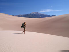
Hiking below Comanche Peak (13,245 ft.).
After a first night camped near Comanche Lake, on the second day of our trek we followed a series of spectacular high trails that stayed well over 12,000 feet for most of the way. I'm glad we had pleasant weather during this stretch, as this was a case when the trail itself was one of the main attractions that allured me to this route.

Walking along the "Phantom Terrace" trail which runs along a narrow ledge with a precipitous drop into the Venable Creek valley below.

Two marmots high in the Sangre de Cristos.

Much of the Sangre de Cristo Range is composed of this unique conglomerate rock, which contains rounded, river eroded stones seemingly cemented together. These old rounded stones originated as eroded debris from the long gone Ancestral Rockies, deposited in alluvial fans and deltas where the matrix of mud and stones hardened into solid rock over millions of years. This rock was later thrust upwards around 15-5 million years ago, forming the mountain range we see today.

A fiery September sunset as seen from San Isabel Lake.
We spent our second night at San Isabel Lake, which I greatly regretted once we passed Rio Alto Lake soon the next morning. San Isabel Lake was okay, but Rio Alto Lake is clearly a much more attractive place to camp. It would have been well worth hiking directly there on the second day instead of taking the detour to San Isabel. For the trip-planner in me, making a mistake like this filled me with the same sort of regrettable feeling that a photographer has when they miss a good photo opportunity! Oh well...

A hiker is dwarfed by the massive Rio Alto Peak in the background.
The area around Rio Alto Peak and Hermit Pass must have been busy with miners long ago, as the trail here followed the remnants of an old road complete with engineered rock walls supporting the switchbacks. It was curious to see such an engineered trail/road in an area that's clearly seldom visited and feels nearly abandoned these days.
An even more intriguing curiosity is that where this old path arrives at Cotton Lake, the path has been completely overtaken by the foot of a large rock glacier, which indicates that: A) the path is indeed quite old; and B) the rock glacier has "flowed" forward since that time. It could be that there is actually still ice at the core of the rock glacier that is still slowing moving, or perhaps the foot of the rock glacier moved forward a bit as the ice melted and the rock glacier "deflated". You can see the rock glacier I'm talking about at the far left side of the photo below, or at the bottom-center of the photo four down from here.

Calm waters of Cotton Lake reflect the rugged peaks above.
While shooting sunrise at Cotton Lake in the morning, I was nearly scared to death by a super loud splash in the water next to me! It was a pair of beavers slapping the water with their tails, no doubt enraged by my presence near their lodge (which I was oblivious to before). But the beavers got used to me soon enough and continued with their business of snuggling and grooming each other atop their lodge. So cute!

A beaver grooms itself atop its lodge along Cotton Lake. If you look closely you might see that it has incorporated a lost (or stolen?) fishing pole into its lodge materials!

The first rays of sunshine illuminate frosted grasses on a chilly September morning.

Overlooking Cotton Lake and the Cotton Creek valley. Like much of the Sangre de Cristo Range, the forests have been devastated by the unprecedented spruce beetle outbreak which has occurred throughout much of Colorado and the Rockies over the last decade or two.
Like many of my trip journals these days, I unfortunately have to talk about the beetle kill yet again. The Sangres have been especially devastated by beetle kill in recent decades; I would estimate that about 90% of the forest in the upper basins is dead, as you can see in the above photo. This is especially depressing to me when it happens in these otherwise paradisiacal high basins around alpine lakes. It feels like a paradise lost, and it's admittedly difficult to appreciate the beauty that remains when you're surrounded by skeleton trees instead of vibrant green forest.
The beetle kill also makes it very difficult or in some cases impossible to find a place to pitch a tent that's totally safe from potential dead fall, which is a particular concern on windy days. In breezy conditions the live trees flex and sway quite a bit with the wind, while the dead trees stay rigid - until they snap. Sometimes if you can't find a safe place to pitch your tent, all you can do is find the potentially least dangerous spot and just try not to be paranoid about the dead trees possibly falling over and crushing you as you sleep. I think this will become (or should become) a higher priority for volunteer trail crews to cut down dead trees around obvious campsites at popular backpacking destinations, though I don't expect this to happen anytime soon in places as remote as this.

Hiking up a tundra slope in front of a striking unnamed pyramidal peak in the Sangres.
Our fourth day of hiking took us on a spectacular off-trail route over the high tundra of a 13,000 ft. peak and down to the Lake of the Clouds on the eastern side of the range. This is yet another gorgeous basin where the forest has unfortunately been wiped out by beetle kill. Nevertheless, the beauty here is still undeniable, especially when the wind calmed down in the evening and a lovely reflection formed in the water.

A beautiful evening reflection in the Lake of the Clouds.
While we were sitting alongside the lake waiting for sunset, some movement in the bushes caught my eye and I looked over and saw the brown fur of a massive animal coming towards us! Of course my immediate thought was: oh shit it's a bear, but then I realized it was a moose - actually two moose! (Or "meese"? 😂). Statistically speaking, moose can be even more dangerous than bears, and their sheer size is intimidating to say the least. The moose were advancing towards us and clearly had the right of way, so I grabbed my tripod and we hastily retreated up the trail to give the moose their space. We didn't want the moose to get between us and our campsite so we hurried back up the trail ahead of them, and from a safe distance near our campsite I set up my camera and waited for them to mosey along the lake shore below us. What an amazing and unexpected encounter!

A moose ambles through the willows along the shore of Lake of the Clouds.
Finally, the last day of our trek was just an uneventful grind on the Rainbow Trail along the eastern foot of the range to get back to our car where we started.
All in all this was a wonderful loop route through the mighty Sangre de Cristo Range, and despite the beetle killed forests there is still plenty of beauty and life to encounter up there!