Backpacking in Kluane National Park
After hiking up King's Throne near Kathleen Lake, we were starting to get excited about the possibility of doing a backpacking trip in Kluane National Park. (Pronounced: "clue on ee"). Plus, we still had a pretty good weather forecast in the Haines Junction and Kluane area of southwest Yukon, while all of Alaska still looked rainy. So we headed out for a three night trek along the west side of Slim's River to the Kaskawush Glacier and back.

Sunrise along Slims River.
We got a late start on our first day and were only able to walk about 10 of the 14 miles (22.5 km) towards the official campsite at Canada Creek. So we pitched our tent for the night on a huge barren alluvial fan. The wind was ripping here, but fortunately we had brought our sturdier winter tent for this purpose, and after building a small rock wall for good measure we were all set for the night.

Morning at camp along Slims River.

Walking up the broad empty glacial flats of Slims River.
The Slims River valley was traditionally the main drainage of the giant Kaskawulsh Glacier, but in recent years the glacier has retreated to the point where the melt water is now flowing out an entirely different drainage! Instead of flowing north 19 kilometres from the glacier's toe into Kluane Lake (and ultimately, the Bering Sea), that melt water is now draining eastward via the Kaskawulsh River towards the Pacific Ocean off the Alaska panhandle. (Source). So now Slim's River is more of just a meandering little creek that intermittently flows through a broad and barren glacial flood plain of sand and mud. As desolate as it looked, it made for some easy hiking on the endless sand and rock flats!

Following fresh grizzly bear tracks up the Slims River valley.
We saw grizzly tracks all over the place on this trek, but never did see the bears themselves.

Hiking up towards Observation Mountain from Columbia Creek.
On day 2 of our trek we decided to push all the way past the Canada Creek campsite and up to the plateau below Observation Mountain to hopefully camp up high for the evening. We weren't sure if we'd find water up there, so we actually started hauling 5 extra liters of water with us up the steep trail. Fortunately before going too far we met some other hikers who confirmed that there was indeed a small spring-fed creek up there, so we immediately dumped all that water!

Hiking to the plateau below Observation Mountain.

The Kaskawulsh Glacier starts from the icefields in the St. Elias Mountains at around 2000-3000 m (6000-9000 ft) elevation, and flows down to about 850m / 2800 ft. It's about 3-4 miles (5-6 km) wide at its broadest point, and covers more than 15,000 square miles (25,000 sq. km) of land.
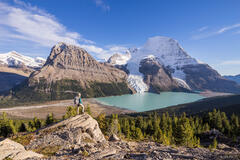
When you finally cross all the meadows and get to the edge of the big of the plateau under Observation Mountain, the sudden view of the Kaskawulsh Glacier is breathtaking! We were stoked to find a flat-enough spot to pitch the tent with a front-and-center view of this monster glacier. The long and strenuous day of hiking with our big packs to get up here felt very much worth it now!

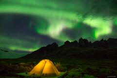
Cozy tent above the cold Kaskawulsh Glacier - Kluane National Park, Canada.
Just for the record, we practiced our best "leave no trace" camping methods here in this pristine location.

Sunrise above the Kaskawulsh Glacier.

Crossing Canada Creek.
On this trek we had plenty of opportunities to hone our river crossing skills. Canada Creek in particular can test one's patience since you have to cross at least a dozen or so of the ice cold river braids, some of which can be quite fast flowing. For the sketchier crossings our preferred method is for me to cross facing upstream with Claudia standing right behind me, holding me with her arms. Not only does this method break the force of the flow for the person behind, but the person behind helps to support the one up front. It works really well! We each also brought an extra pair of trail runner shoes specifically for river crossings, which was invaluable.

Hiking back along Slims River.
After a third and final evening at the Canada Creek campsite, we hiked all the way back out along Slims River.
With all the grizzly tracks, river crossings, the glacial valley, desolate mountains, and trailless miles, this trek definitely felt quite wild. Certainly a lot more wild than the average backpack trip back home in Colorado! And although a week prior we had never even heard of Kluane National Park, our memorable trek here ended up being one of the highlights of our summer!