Smoked out of the Winds
In late August we hit the road headed west towards the Sierra Nevada in California, where we had two exciting backpack trips planned. After two days of driving we arrived in Tonopah, Nevada, our last stop before our trailhead in the eastern Sierra. That's when I got online and saw that a big wildfire had erupted on the western slope of the Sierra and was pumping smoke directly over the areas where we'd planned to go! NOOOOO!!!! Our treks were doomed, so the next day we turned around and drove back home. ☹️ Dumbest road trip ever. (In retrospect, that was indeed the right call, as the Garnet Fire has since grown to nearly 60,000 acres and continues to pump smoke over the areas where we would have been trekking).
After a few days of decompressing back at home and a fair amount of indecision, we finally decided to make the most of our two weeks off so we repacked our backpacks and headed to a different mountain range – the Wind River Range in Wyoming. With lots of granite peaks and big lakes, the "Winds" are almost like the Sierra of the Rockies, and a mighty fine backup option after all!
Of course before we left again I spent more time researching the current wildfire/smoke conditions in Wyoming. There was actually a wildfire on the northern end of the Winds, but recent rainy weather had reduced that fire to smoldering and it looked like the only smoke to worry about would be sporadic periods of haze wafting over from wildfires in Oregon. So we drove up to Pinedale, spent a night there, then ventured out on our planned 6-day loop trek early the next morning.

Soaking in the view on a lakeside granite "patio" on a pleasant evening in the Wind Rivers.
For the first leg of our trek we hiked 12 miles to a lovely lake that I had camped at during a previous 10-day trek in September of 2019. We walked right up to the same exact campsite I stayed at before, and soon enough we were sitting on the same granite peninsula where I had relaxed at almost exactly 6 years before. After a quick swim in the lake, we chilled in our camp chairs on a flat granite slab, enjoying the views of the surrounding peaks reflected in the calm water and feeling pretty satisfied about our decision to come all the way up here after all!
The Wind Rivers are easy mountains to fall in love with. They feel like an ideal combination of the granite peaks and lakes of the Sierra along with the meadows and forests of the Colorado Rockies. It's a backpacker's paradise for sure, and one huge benefit of backpacking in the Winds in September is that the notorious mosquitos are all gone. It's so nice to be able to lounge outside and soak in the views without being swarmed by those little vampires!

Sunset light on Fremont Peak (13,704 ft), reflected in Island Lake.
On the second morning we left our quiet lake and hiked over a pass to the uber-popular Island Lake. I had hiked past here on my 2019 trek, but Claudia hadn't seen this valley before so I was excited to show her this amazing part of the Winds. Sure enough there were numerous groups of campers scattered around here, though it was likely only a fraction of the crowds that must have been here several days prior during the busy Labor Day weekend. It's a spectacular place but pure solitude should not be expected here! But it's a big lake and there's space to spread out.
We enjoyed another pleasant evening here overlooking the lake, watching the changing light on the rugged walls of Fremont Peak in the background.

Relaxing on granite slabs along Titcomb Lakes.
After two solid days of hiking, our third day's hike was a welcome shorter day of continuing up the valley to the famous Titcomb Lakes – a series of large lakes set in a broad, glacier-carved valley ringed by jagged peaks. We found a secluded spot to pitch our tent (200 feet away from the shore, of course), then scouted around for a perfect spot to swim and chill out by the lake for hours in the afternoon.
There's something special about camping in granite mountains, especially when there are broad granite slabs sloping into lakes. This is a sort of holy grail of epic camping spots; lakeside granite slabs are like the alpine equivalent of a beautiful tropical beach. And there's no shortage of granite and lakes in the Wind Rivers!

Smoke and ash from the Dollar Lake Wildfire fills Titcomb Basin in September 2025.
In the late afternoon we were surprised when a wall of thick smoke and haze pushed in over the mountains to the north. This was too much smoke to be drifting in from a far off state – this had to be from a much closer fire. Soon enough white ash began snowing from the sky, and even black charcoal pine needles wafted down on upon us. We were grateful to have brought masks just in case, which helped to keep the nasty smoke and ash out of our lungs.
I started to wonder if this smoke was from a new, closer fire that we might need to worry about, so I used my inReach satellite messenger to text a buddy of mine back home, asking him to check the fire/smoke maps. He replied soon, informing me that the same Dollar Lake Fire on the northwest end of the range had flared up again after the previous days' heat and wind. (Sadly what was causing all this smoke and ash was that the fire had expanded south into the Bridger Wilderness and was devouring the entire mountainside of forest along the west side of the iconic and beautiful Green River Lakes, and then even deeper into the Porcupine Valley).

A smoky sunset reflection in Titcomb Basin in the Wind River Range.
Fortunately for us the winds shifted and the thickest smoke cleared out right before sunset and during much of the night. The smoke clouds made for quite surreal sunset light over Titcomb Lakes!

Camping in the moonlight at Titcomb Lakes.
The wildfire was far enough away over the mountains that we weren't in any imminent danger, but it was clear that we probably should not continue our planned loop route, which would have taken us over a high pass directly into the head of the valley upstream of the fire. I struggled to give up my hopes for continuing the trek, which would have been a spectacular route that I was very excited to do. But with the weather forecast calling for continuing winds from the direction of the fire, eventually I accepted that it would be foolish to do strenuous hiking in the smoky air and possibly spend another day and evening sitting in the direct path of ash and smoke. So in the morning we packed up and reluctantly retreated back down the trail from Titcomb Lakes towards the trailhead.

Wading across an outlet of Titcomb Lakes on a chilly September morning.

Pyrocumulus clouds from the Dollar Lake Wildfire waft in the sky above Elklund Lake, September 2025.
After we'd hiked about 10 miles, give or take, we decided to spend a final night at Elklund Lake. Here we were far away enough that we weren't in the direct blast zone of the wildfire smoke, and from the lake we could see where the smoke was billowing up into a huge pyrocumulus cloud. It was a somber and apocalyptic atmosphere.

The moon shines through a wildfire smoke filled sky in the Wind Rivers.
While I was disappointed to have to cut our trek short, and of course even more bummed that the beautiful area around Green River Lakes was burning up, I was still grateful that we got to savor three nice days in the Wind Rivers before we got smoked out. And it was also quite a unique and surreal experience to be out in the mountains amidst so much smoke and ash; albeit one that I wouldn't want to repeat.
A New Normal
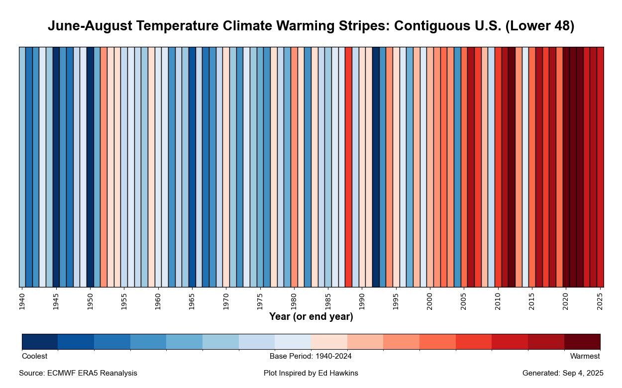
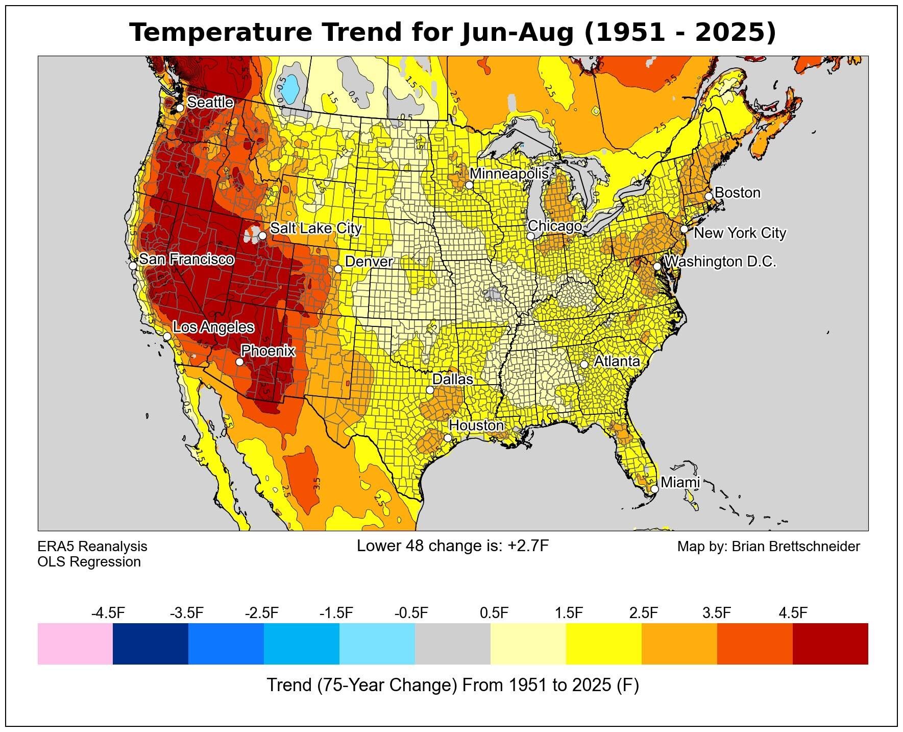
This summer of 2025 has been yet another season of smoke-filled skies from wildfires throughout the western US and Canada. Colorado had big wildfires in July, and I know there have also been many wildfires in California, Oregon, Washington, Idaho, and of course Wyoming. If, like me, you feel like this has been happening more and more often in recent years, you are not wrong. It's not too difficult to connect the dots between wildfires and temperature data: