Through the Collegiate Peaks Wilderness
This last week, in mid-July, we ventured out into the Sawatch Range for a 4-day, 25-mile, one-way shuttle trek through the southern bulk of the Collegiate Peaks Wilderness west of Buena Vista, Colorado. The Collegiate Peaks Wilderness has the highest average elevation of any wilderness area in the United States, and includes eight 14ers (mountains over 14,000 feet elevation), five of which are named after Ivy League universities (thus the name of the wilderness). Our backpacking route took us directly over two of these fourteeners - Mount Harvard and Mount Belford.

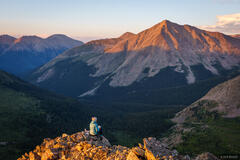
Thunderstorm clouds over Mount Yale (14,196 ft.) after passing over Hartenstein Lake.
After driving there and shuttling vehicles from our end point to the starting point, we got an afternoon start and hiked up to Hartenstein Lake for our first night. Unfortunately our timing was just about 20 minutes too late, and the skies unleashed with thunder and blowing sheets of rain before we could find a good campsite and set up the tent. Recurring waves of thunderstorms, swarms of mosquitos, and driving rain for most of the night made this kind of a grim evening of camping to be honest.

A marmot keeping an eye on us on Browns Pass.
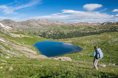
On Day 2 we enjoyed a beautiful hike over a vast high tundra pass, down through the next valley, then up to the Horn Fork Basin below the fourteeners Mount Harvard and Mount Columbia.
For Day 3 my ambitious plan was to wake up super early and hike up Mount Harvard in the dark in order to be on the summit for sunrise. But again it rained for most of the night, and when my alarm clock woke me at 2am it was still raining. Damn... But, being stubborn about my plans, I figured surely it would stop raining at some point, so I just put my clothes on anyways and started getting ready for a wet and dark hike. Miraculously, by the time I got out of the tent, not only had it stopped raining but the sky was completely clear and starry! Nice!

Sunrise panorama from the 14,420 ft. summit of Mount Harvard, the third highest 14er in Colorado, looking south towards Mount Yale and Mount Princeton, two other fourteeners in the Sawatch Range.
As usual, the crux of the morning was just waking up and deciding to go, then the hike up Mount Harvard in the dark was just a matter of grinding it out up the well-trodden 14er trail with my bright headlamp to illuminate the way.
At 14,420 feet tall, Mount Harvard is the third highest 14er in Colorado, and in my opinion offers one of the best summit views of the 14ers. From the top you can see the majority of the mountain ranges of the state - from the San Juans far in the distance to the southwest, to the Sangres in the south, the Elk Mountains in the west, all the way up to the Gore Range to the north, and the Front Range even further.

Sunrise light shines around Pikes Peak (14,110 ft.), as seen from far away on the summit of Mount Harvard.
Though the sunrise was short-lived due to clouds in the east, I still had fun photographing from the summit, particularly picking out distant peaks with my telephoto lens.

A view of two 14ers from the summit of Mount Harvard: Huron Peak (14,003 ft. in the Sawatch Range) with Castle Peak (14,265 ft. in the Elk Mountains) in the background.

The north side of Mount Yale (14,196 ft.) as seen from the summit of Mount Harvard.
After about three hours or so up there by myself, the day's 14er hikers started showing up, and eventually Claudia (who slept in while I was doing my pre-dawn hike) joined me at the summit and we found a nice spot out of the wind to cook our morning coffee and oatmeal while soaking in the immense views.

Geologists say that during the Ice Age about 2 million years ago, the Sawatch Range was almost completely covered with ice sheet and glaciers, with only the highest ridges emerging through the ice. When overlooking the vast expanse of Missouri Basin, it's easy to imagine it filled with a broad glacier in the not-so-distant geologic past.

Hiking on a high ridgeline in the Sawatch Range as a massive thundercloud brews.
As the first little puffy clouds started forming, we knew we'd better get going before the thunderstorms brewed. Sure enough, before we were even 1,000 feet below the summit, the little puffy clouds had ballooned into towering cumulus clouds. We picked up the pace a bit.

Sunlight shines on Mount Belford (14,197 ft.) with a dark thunderstorm behind. Lightning bolts were striking behind the peak, though I wasn't lucky enough to catch one with the camera.
By the time we had made it down from Mount Harvard's ridge into the next basin, there were black clouds the next ridge over, and we watched lightning bolts striking just over Mount Belford as thunder rumbled.
With more waves of thunderstorms (and more swarms of mosquitos) we spent much of the afternoon in the tent, which was fine by me as I needed a nap after my 2am start that morning!

A gorgeous sunrise as seen from a remote lake in the Sawatch Range.
On our fourth and final day of our trek, we were treated to a glorious cotton-candy sunrise above the remote lake where we were camped near. So far on this trip I had felt like I'd been mostly skunked for good light, so it was a big pleasure to score a spectacular show on our final morning!

Cotton candy sunrise over Mount Harvard (14,420 ft.).
After sunrise and lakeside coffee and breakfast, we had a wonderful day of hiking all the way around Missouri Basin, a remarkably broad, immense basin surrounded by 14ers and 13ers. After crossing over Elkhead Pass it was just a quick jaunt up to the 14,197 ft. summit of Mount Belford for the easiest 14er bagging that I've ever done (since our route already brought us up so high anyways). With dark thunderclouds brewing yet again, tagging the neighboring Mount Oxford fourteener was out of the question and we scurried down Belford and Missouri Gulch back to our car (and potato chips!) waiting for us there.

A ptarmigan in its natural habital high on the slopes of Mount Belford, with a view of Missouri Mountain (14,067 ft.) behind. This momma ptarmigan was vigilantly guarding about six super-cute little baby ptarmigans, but they scurried off before I could snap a photo.
As always, it was super fun and satisfying to plan out and hike a novel and adventurous route through the mountains and to visit some basins and peaks that I've long desired to see.