A Semi-Traverse of La Sals
At the end of May/beginning of June, we headed over to La Sal Mountains above Moab, Utah, for our first mountain backpack adventure of this summer. The route I had in mind more or less traced the same route I did as a ski traverse of the northern La Sals back in 2008 with my friends Ann and Seth - except this time we were walking instead of skiing, we did a loop trek instead of a one-way shuttle, we stuck to the ridges instead of dropping into various basins, and we camped two nights along the way instead of powering through in one day. One similarity of the trips was cold temps and an excess of snow in some of the valleys - perhaps we jumped the gun by a week or two on this trip!

Freshly budded aspens at Warner Lake in La Sal Mountains above Moab, Utah - late May.
The freshly budded aspens were looking vibrant as we left our car at Warner Lake and started hiking through the forest.

Springtime aspens at the end of May in La Sal Mountains.
Once through the beautiful aspen forests, we fairly soon ran into snowpack still covering the trail in the shaded pine forest valley. Since it was already late in the afternoon, I was worried about getting bogged down postholing through the snowpacked valley in the dark, so we ended up bushwhacking straight up a steep and rocky south facing slope to gain the ridge instead. Having to haul all our water up for the night and next day didn't help either! I was cursing myself for not bring enough fuel to melt snow instead.

Looking north from the summit of Manns Peak (12,272 ft / 3740 m).
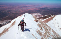
Our struggles during the first day's hike and a chilly, breezy camp was all prep for the real prize of this trip on the second day: a glorious day of walking up and down along the crest of the mountains with supreme aerial views over the canyonlands the entire way! In the photo above you can see most of our route for the day.

Pleasant ridgeline walking on the crest of the northern La Sal Mountains.
A defining characteristic of La Sals are the gentle ridges which connect seamlessly from peak to peak, offering a very pleasant high altitude stroll across the range - when the wind is not blasting, that is. We were fortunate to have relatively calm weather during our trip (unlike my previous ski traverse of the range, when the wind was nuking the entire time!).

Hiking down from Green Mountain, with expansive canyonlands near Moab stretched out far below.
La Sal Mountains rise over 8,000 vertical feet above the town of Moab and surrounding canyonlands, so the views from up top almost feel like you're looking out of an airplane. Canyon walls that seem enormous from down below look like tiny little bumps from this high up. The view radius from up here is expansive to say the least - to the west and north: all of Canyonlands and Arches National Parks, Henry Mountains, Capitol Reef, and San Rafael Swell; to the east: Grand Mesa, the entire Uncompahgre Plateau, and the San Juan Mountains. It was fun to gaze over the landscape and point out all the various places we've explored and adventured over the years.

Our tent doubling as a solar snow melter.
We found a neat spot to camp up high at treeline but there was no water to be found anywhere and we didn't bring enough fuel to melt snow. What to do? I summoned my inner MacGyver and spread snow over our tent as solar melting station, complete with a reservoir dam at the bottom. It worked like a charm and within an hour or so we had 8 liters of water. Success!

A mountain goat high in La Sal Mountains above Moab, Utah.
While hanging out at our high camp, Claudia noticed four little white dots moving along the mountaintop across the way. I was surprised when I inspected with my telephoto lens and confirmed they were mountain goats! Seems like an odd place for mountain goats to live, on an alpine island surrounded by canyons and desert. I wasn't aware of this previously, but a quick internet search taught me that in 2013, in a controversial move the Utah Division of Wildlife Resources released 20 non-native Rocky Mountain goats into La Sals (and 15 more the next year) for hunting and "wildlife viewing", despite opposition from the regional Forest Service office and numerous local and national environmental groups. People are strange. "Hey, let's helicopter in a bunch of mountain goats to this desert mountain range so that they can thrive and then we'll charge people to shoot them!" What a plan.

Rich sunset light on Mount Tukuhnikivatz (12,482 ft) in La Sal Mountains.
I returned back up to the nearby high peak to photograph the sunset light and then savored the extraordinary dusk colors that you can only see from high atop a mountain over the desert.

Crescent moon and rich dusk light above the southern Utah desert, as seen from high up in La Sal Mountains.

Hiking down into the aspen forests of Miners Basin, with the canyonlands beyond.
Our third and final day took us down off the high peaks and back into the green world of spring aspens. But the challenges weren't over yet - we still had one more pass to get over to get back to our car, through another valley still full of snowpack. In another attempt to avoid postholing through snow, we veered off trail and ended up doing a heinous bushwhack up a steep mountainside. Claudia was about to strangle me, and even I (who typically enjoys an occasional bushwhack) was feeling anxious about our progress. But eventually we persevered, gained the pass, and after a relaxing break and some heartfelt apologies we enjoyed a clear trail all the way down through the aspens back to our car.
Did we jump the gun on this trip? Yes, absolutely. Would I do it again? Yes, absolutely. But maybe a little later in the summer next time.