Summer Above Moab
Last weekend I drove out towards Moab, Utah again for the fourth time this year. This time, though, instead of a canyon trip, I ventured up into La Sal Mountains which rise over 8,000 vertical feet above Moab like an alpine island towering over the surrounding desert and canyons. I had an ambitious plan for a 3-day, 30+ mile trek around and over the whole range, though I ended up having to scale back my plans on the fly.

A path through a lush, flower-lined aspen forest in La Sal Mountains above Moab, Utah.
In early June the aspen forests on the flanks of La Sals are bursting with greenery, wildflowers, and birdsong. Early summer is in high gear!
14 miles of hiking around the western side of the range brought me to my first camp in a meadow next to an aspen forest below the south side of Mount Tukuhnikivatz (or, "Tuk" for short).
My plan for the next two days was to hike the high ridges all the way from Tuk to Mount Waas on the northern end of the range; however, soon on the second morning after reaching the crest I could see that my intended route was blocked by a rugged cliffband on Talking Mountain. If I'd been more determined I probably could have carefully scrambled up and around through there, but the steep crumbly rock looked precarious and it just didn't seem worth the effort or risk to me.
Consulting my map, I decided to abandon my ambitious ridge route and descend into Gold Basin, where a little alpine lake and pleasant meadow looked quite inviting for a camp spot. After hours of chilling out there and even an afternoon nap, I motivated to hike up a nearby peak to watch sunset from up high!

The setting sun beams through curtains of rain above the town of Moab, as seen from 12,000 feet high in La Sal Mountains.
Although the sky had been totally clear all day, once I reached the ridge above treeline I could see thunderheads in the distance. Having cell reception up there, I consulted my weather radar and lightning apps and could see that there was indeed lightning over Capitol Reef National Park to the west and the Book Cliffs to the north. It was pretty surreal to be so high up in the mountains looking across such vast distances at thunderclouds sweeping across the desert.

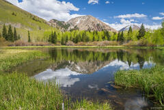
Mount Tukuhnikivatz (12,500 ft) towering above Gold Basin at dusk. A lone thundercloud and the Henry Mountains are visible in the far distance to the right.
After enjoying and photographing the sunset (and the amazingly vibrant dusk glow that is almost incomparable when seen from high in La Sals looking west over the vast desert), I retraced my route back down to camp by headlamp.

Storm clouds build over Mount Tukuhnikivatz and the aspen forests of La Sal Mountains.
I slept in on the third morning, then packed up and walked the final 10 or so miles back to my car, passing through the charred forests burned in the 2021 Pack Creek Fire (caused by an unattended camp fire).
Although I wasn't able to do the high ridge route I had hoped to, and my route ended up being unnecessarily long for what I actually ended up doing, it was still a good trip to shake off the winter's rust from my legs, get my first alpine immersion of the summer, and explore some more of the unique La Sal range.